![]()
SENEGAL
Expedition Journal
Photographs
Origins
Symbols
Regions
Languages
History
Government
Economy
Geography and Climate
Population, Ethnic Groups, Culture and Religion
Fauna and Flora
Environment
Resource Links
Lesson Plans
Check out the Route Maps
Send us an Email
Camping Information
|
Expedition |
|
Lend a Helping Hand You can help make the Virtual Classroom available to students by making a donation today. |
| World of Wonders Project: The West Africa Expedition |
|
Senegal
|

Click on either map to see it in detail
|
|
| Origin of the name Senegal | Official name is Republic of Senegal. The origin of the name is confusing. Some believe that the country is named after the river of the same name that runs along its northern border before entering the Atlantic Ocean. Other believe the name Senegal comes from the African Wolof Tribe name of a dugout canoe in the land of Teranga (hospitality). | ||||
|
Symbols
|
Click on each link below to learn more about the symbols.
|
||||
|
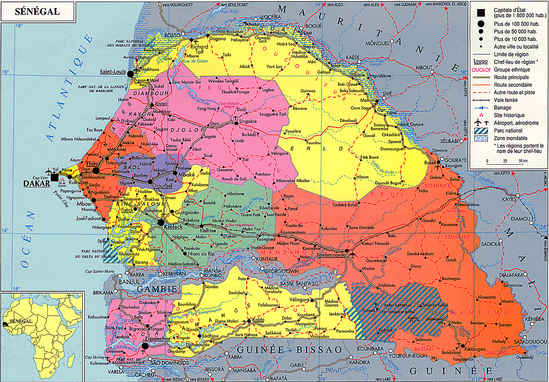
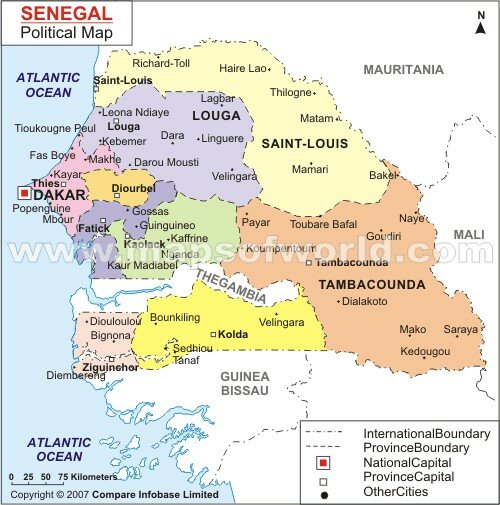
Regions
|
(Click on any map to see it in detail)
|
||||
| Language | Official languages are French and Wolof, with Pulaar, Jola, and Mandinka also spoken. | ||||
|
History
|
History Archaeological findings throughout the area indicate that Senegal was inhabited in prehistoric times. Islam established itself in the Senegal River valley in the 11th century. In the 13th and 14th centuries, the area came under the influence of the Mandingo empires to the east; the Jolof Empire of Senegal also was founded during this time. www.electionworld.org/history/senegal.htm www.jangawolof.wordpress.com/2008/05/23/a-short-history-on-senegal/ |
||||
| Government |
Government
Senegal is a republic with a presidency; the president is elected every five years. The current president is Abdoulaye Wade, re-elected in March 2007. The president of the republic determines national policy and appoints the prime minister and his council of ministers. As presently constituted, the constitution does not give the president the authority to dissolve the National Assembly or to veto legislation. However, if the National Assembly is requested to reconsider a measure it has enacted, the bill must be passed again by a three-fifths majority before it becomes law. The president also may ask the Supreme Court to rule on the constitutionality of a proposed law. With the consent of the president of the National Assembly and the Supreme Court, the president of the republic may submit any proposed law to national referendum. Legislative power is exercised by the 120-member (formerly 140-member) National Assembly, elected to serve five-year terms. The Assembly elects the 16 members of the High Court of Justice from among its ranks. Members of the Council of Ministers may not be Assembly members, and are appointed by the prime minister in consultation with the president. The former senate, established in 1998, had 60 members, 48 elected by an electoral college (legislators and local, municipal and regional councilors), and 12 appointed by the president. www.nationsencyclopedia.com/Africa/Senegal-GOVERNMENT.html |
||||
| Economy |
Economy Predominantly rural and with limited natural resources, the Economy of Senegal gains most of its foreign exchange from fish, phosphates, groundnuts, tourism, and services. Its agricultural sector is highly vulnerable to variations in rainfall and changes in world commodity prices. Dakar, as the former capital of French West Africa, is also home to banks and other institutions which serve all of Francophone West Africa, and is a hub for shipping and transport in the region. Natural resources: Fish, peanuts, phosphate, iron ore, gold, titanium. WEIGHTS AND MEASURES: Metric weights and measures are used. |
||||
| Geography and Climate |
Geography: The country's total area is 196 190 km² of which 192 000 km² is land and 4 190 km² is water, making the nation slightly smaller than Britain or the U.S. state of South Dakota. There are four areas on the World Heritage List:
wikipedia.org, unesco |
||||
|
Population
Culture and Religion |
Population Senegal has an estimated 2008 population of nearly 13 million, about 70 percent of whom live in rural areas.
The largest ethnic group is the Wolof, who made up 43.3% of the total population in 1998; they live mainly in the northwest. The Pular rank as the second-largest group, constituting 23.8%. Closely related to the Wolof are the Serer (14.7%), in west-central Senegal, who are skilled peanut cultivators, and the Lebu, mostly fishermen and farmers, concentrated in the Dakar area.
Other important groups are the Diola of Casamance, making up 3.7% of the populace; the Mandink, in the southeast and in Casamance, accounting for 3%; the Soninke constituting 1.1%; the Tukulor, who live predominantly in the northeast; and the Fulani (Peul) and Bambara, scattered throughout the country. Europeans and Lebanese make up about 1% of the total population; other various groups constitute the remaining 9.4%. The religious division is Muslim 94%, Christian 5% (mostly Roman Catholic), indigenous beliefs 1% www.cia.gov/library/publications/the-world-factbook |
||||
| Fauna and Flora |
Fauna and Flora Vegetation varies in different areas of Senegal, depending on the average rainfall. The most tropical part of southern Casamance has mangrove swamps and remnants of high forest, including oil palms, bamboo, African teak, and the silk-cotton tree. The dry thornland of the northeast has spiny shrubs, especially acacia, including the gum-bearing species. Most of Senegal is savanna. Trees, which are widely spaced in this region, include the African locust bean, tallow tree, and gingerbread plum, along with cassias and acacias. The lion and leopard are rare, occasionally found in the northeast, as are chimpanzees, elephants, hippopotamuses, and buffalo. The wild pig, hare, guinea fowl, quail, and bustard are widely distributed. Insects and birds are abundant, and there are numerous lizards, snakes, and other reptiles. |
||||
| Environment |
Environment
Approximately 46% of Senegal is classified as semiarid. Much of the land is threatened with desertification because of overgrazing, inadequately controlled cutting of forests for fuel, and soil erosion from overcultivation. According to a UN report, at least 4.5% of Senegal's forests have been eliminated. By 1985, the total amount of land subject to deforestation was 193 square miles. Between 1983 and 1993, an additional 4.4% of the nation's forest and woodland was lost. Dakar suffers from such typical urban problems as improper sanitation (especially during the rainy season, when sewers overflow) and air pollution from motor vehicles. The nation has 26 cubic kilometers of renewable water resources with 92% used for farming activity and 3% used for industrial purposes. About 92% of the nation's city dwellers and 65% of the people living in rural areas have access to safe drinking water. Senegal's cities produce about 0.6 million tons of solid waste per year. Important environmental agencies include the Ministry of Scientific and Technical Research, which is responsible for coordinating all research and development in Senegal. Encyclopedia of the Nations |
||||


|
We thank our West Africa Expedition Sponsors Please visit their websites
|

|
Contact us for information regarding sponsorship opportunities.
Join the Virtual Classroom. Complete the free registration form for your classroom today. Support the expeditions. Your donation will help to continue the research, documentation and Virtual Classroom web site presentation of these wonderful cultures and experiences to the broadest possible audience. To find out how you can help, please follow this link to our Helping Hand page. Thank you, now it's time to explore!
|