![]()
MAURITANIA
Expedition Journal
Photographs
Origins
Symbols
Regions
Languages
History
Government
Economy
Geography and Climate
Population, Ethnic Groups, Culture and Religion
Fauna and Flora
Environment
Resource Links
Lesson Plans
Check out the Route Maps
Send us an Email
Camping Information
|
Expedition |
|
Lend a Helping Hand You can help make the Virtual Classroom available to students by making a donation today. |
| World of Wonders Project: The West Africa Expedition |
|
Mauritania
|
|
Click on map to see it in detail |
|
| Origin of the name Mauritania | Official name is: Islamic Republic of Mauritania. It is generally agreed that the name came from the ancient regions of Mauretania named after the Moors who lived there. | ||||
|
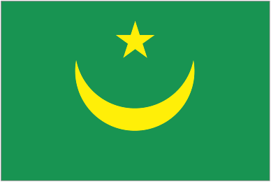
Symbols
|
Click on each link below to learn more about the symbols.
|
||||
|
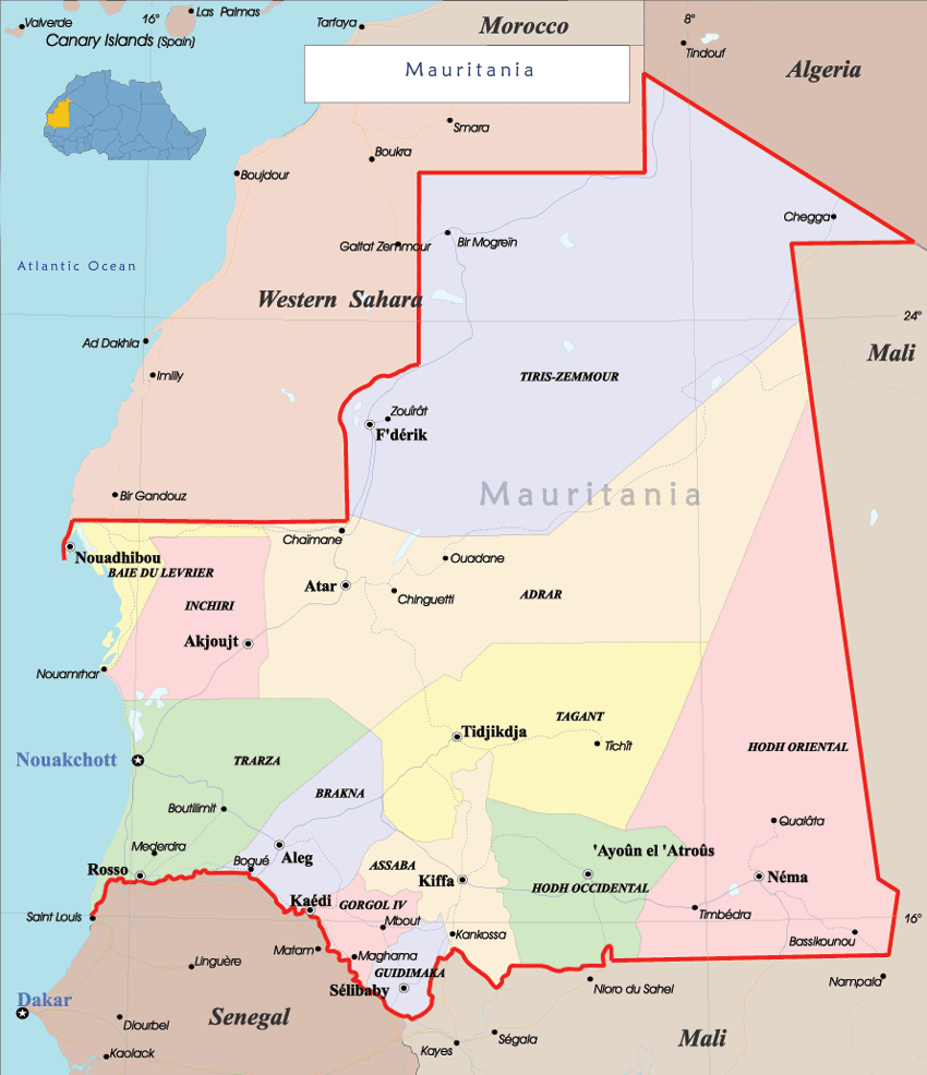
Regions
|
 (Click on any map to see it in detail)
|
||||
| Language |
Official language is Arabic. The Arabic spoken in Mauritania is called Hasaniya. Wolof, Peular (Pulaar), and Soninke are spoken in southern Mauritania and recognized as national languages; Wolof is also recognized as an official language. French is widely used, particularly in business, but its status as an official language was eliminated in the 1991 constitution.
Source: Encyclopedia of the Nations |
||||
|
History
|
History Mauritania was first inhabited by blacks and Berbers, and it was a center for the Berber Almoravid movement in the 11th century, which sought to spread Islam through western Africa. It was first explored by the Portuguese in the 15th century, but by the 19th century the French gained control. They organized the area into a territory in 1904, and in 1920 it became one of the colonies that constituted French West Africa. In 1946, it was named a French Overseas territory. Mauritania became an independent nation on Nov. 28, 1960, and was admitted to the United Nations in 1961 over the strenuous opposition of Morocco, which claimed the territory. In the late 1960s, the government sought to make Arab culture dominant. Racial and ethnic tensions between Moors, Arabs, Berbers, and blacks were frequent. Mauritania and Morocco divided the territory of Spanish Sahara (later called Western Sahara) between them after the Spanish departed in 1975, with Mauritania controlling the southern third. The Polisario Front, indigenous Saharawi rebels, fought for the territory against both Mauritania and Morocco. Increased military spending and rising casualties in the region helped bring down the civilian government of Ould Daddah in 1978. A succession of military rulers followed. In 1979, Mauritania withdrew from Western Sahara. In 1984, Col. Maaouye Ould Sidi Ahmed Taya took control of the government. He relaxed Islamic law, fought corruption, instituted economic reforms urged by the International Monetary Fund, and held the country's first multiparty parliamentary elections in 1986. Although the 1991 constitution set up a multiparty democracy, politics remains based on ethnic and racial lines. The primary conflict is between blacks, who dominate southern regions, and the Moorish-Arabic north, which runs the country. Racial tensions reached a peak in 1989 when Mauritania went to war with Senegal in a dispute over the border. As each country repatriated citizens of the other, critics accused Mauritania of taking the opportunity to expel thousands of blacks. Although Mauritania officially abolished slavery in 1980, the nation continues to tolerate the enslavement of blacks by North African Arabs. In 1993, the U.S. State Department estimated that there were more than 90,000 chattel slaves in the country. In 1992, Taya won the nation's first multiparty presidential election, which opponents charged was rigged. Taya's attempts to restructure the economy provoked periodic protests, the most serious of which were the bread riots in Nouakchott in 1995. In 2002, the government banned a political party, Action for Change (AC), which has campaigned for greater rights for blacks, calling it racist and violent. Two other opposition parties have been banned in the past few years. The IMF granted Mauritania debt relief in June 2002, wiping out $1.1 billion, half of Mauritania's overall debt. Coup attempts in June 2003 and Aug. 2004 were thwarted. Taya's crackdown on Islamists and his support for Israel and the U.S. were believed to have sparked the attempts to overthrow him. In Aug. 2005, however, President Taya was deposed by military officers while out of the country. In June 2006, voters approved to limit the presidency to two five-year terms. Mauritania started its march toward democracy in November 2006, when local and regional elections were held throughout the country. Presidential elections followed in March 2007. None of the 19 candidates won more than 50% of the vote in the first round, and the two top candidates, Sidi Ould Sheik Abdellahi, a former government minister, and Ahmed Ould Daddah, an opposition leader, faced off in the country's first-ever second round of voting. Abdellahi prevailed in the runoff to become the country's first democratically elected president. In July 2008, the country's top four military leaders deposed Prime Minister Boubacar and President Abdellahi in a bloodless coup. Some of the same military leaders were involved in the 2005 coup that brought Abdellahi to power. In recent months, the country's legislature had criticized Abdellahi's handling of rising food prices and accused the government of corruption. Source: www.infoplease.com |
||||
| Government |
Government
The first fully democratic Presidential election since 1960 occurred on 11 March 2007. The election is the final transfer from military to civilian rule following the military coup in 2005. This is the first time the president will have been selected by ballot in the country's history. wikipedia |
||||
| Economy |
Economy
Gross Domestic Production (GDP) (2006): $1.6 billion, Per capita income (2006): $630.
Natural resources: petroleum, fish, iron ore, gypsum, copper, gum Arabic, phosphates, salt and gold.
Agriculture (22.3% of GDP 2005): Products--livestock, traditional fisheries, millet, maize, wheat, dates, rice. Industry (19% of GDP 2005): Types--iron mining, commercial fishing. Services (58.7% of GDP 2005).
Trade: Exports (f.o.b.)--$623 million (2006). Export partners--Italy 18.9%, France 17.4%, Germany 13.8%, Belgium 13%, Japan 12.6%, Spain 11.7%, China 2.1% (2006). Imports--$1,083 million (2006): foodstuffs, machinery, tools, petroleum products, and consumer goods. Import partners--France 15%, Brazil 5.9%, China 5.5%, U.S. 5.5%, Belgium 4.8%, Spain 3.4% (2006).
Currency: Ouguiya (UM). There are coins of 1 khoum and 1, 5, 10, and 20 ouguiyas, and notes of 100, 200, 500, and 1,000 ouguiyas. $1 = UM225 as of September 2008. Source: U.S. Dept. of State 2008
Weights and Measures: Metric weights and measures are used.
|
||||
| Geography and Climate |
Geography Area: 1,030,070 sq. km. (397,710 sq. mi.) Mauritania, three times the size of Arizona, is situated in northwest Africa with about 350 mi (592 km) of coastline on the Atlantic Ocean. It is bordered by Morocco on the north, Algeria and Mali on the east, and Senegal on the south. The country is mostly desert, with the exception of the fertile Senegal River valley in the south and grazing land in the north. Mauritania has four ecological zones: the Saharan Zone, the Sahelian Zone, the Senegal River Valley, and the Coastal Zone. Although the zones are markedly different from one another, no natural features clearly delineate the boundaries between them. Sand, varying in color and composition, covers 40 percent of the surface of the country, forming dunes that appear in all zones except the Senegal River Valley. The Senegal River is the only permanent river between southern Morocco and central Senegal. From its source in Guinea, it flows north and west 2,500 kilometers, reaching the Atlantic Ocean at Saint Louis, Senegal. From its mouth, the river is navigable as far as Kayes, Mali, during the rainy season and Podor, Senegal, during the rest of the year. Heavy rains, beginning in April in Guinea and May and June in Senegal and Mali, bring annual floods. These floods cover the entire valley up to a width of twenty-five to thirty-five kilometers, filling numerous lakes and sloughs (marigots) that empty back into the river during the dry season. When the waters recede from the bottomlands, planting begins. Source: www.infoplease.com 2008, U.S. Dept. of State 2008, www.countrystudies.us 2008 Climate Maurtania’s climate is predominately hot and dry with the Saharan Zone making up the northern two-thirds of the country. Rain usually falls during the hivernage, which lasts from July to September and often, isolated storms drop large amounts of water in short periods of time. However a year, or even several years, may pass without any rain in some locations. During December and January, temperatures range from an early morning low of 0°C to a mid-afternoon high of 38°C. During May, June, and July, temperatures range from 16°C in the morning to more than 49°C by afternoon. The harmattan is the prevailing wind. Throughout the year it often causes blinding sandstorms. The hivernage begins earlier in the Sahelian Zone than in the Saharan Zone, often lasting from June until October. Although temperature extremes are narrower than in the Saharan Zone, daily variations range from 16°C to 21°C. The climate of the Senegal River Valley contrasts with that of the Saharan and Sahelian zones. Rainfall is higher than in other regions, ranging from 400 millimeters to 600 millimeters annually, usually between May and September. This rainfall, combined with annual flooding of the river, provides the basis for agriculture. Temperatures are cooler and subject to less variation than in other regions. The Coastal Zone extends the length of the approximately 754-kilometer-long Atlantic coast. Prevailing oceanic trade winds modify the influence of the harmattan, producing a humid but temperate climate. Rainfall here is minimal; in Nouadhibou it averages less than three centimeters annually and occurs between July and September. Temperatures are moderate, varying from mean maximums of 28°C and 32°C for Nouadhibou and Nouakchott, respectively, to mean minimums of 16°C and 19°C. Source: www.countrystudies.us
There are two sites in Mauritania on the World Heritage List:
|
||||
|
Population
Culture and Religion |
Population, Ethnic Groups, Culture and Religion Population (2005 estimate): 2,906,000. Ethnic groups: Arab-Berber (White Moor), Arab-Berber-Negroid (Black Moor), Haalpulaar, Soninke, Wolof (Black African Mauritanians). Culture: Family and kinship groups are the predominant social units. As elsewhere in Africa, kinship groups are preserved by interaction and social support, shared religious observances, and rituals celebrating stages of the life cycle of individuals. The sharing of rituals reinforces group solidarity and the values the kinship system embodies. Traditionally, one of the most common kinship groups throughout Mauritania is the lineage, or descent group. Lineages generally share responsibility for socializing the young and maintaining conformity to social norms. Lineage elders often meet to settle disputes, prescribe or enforce rules of etiquette and marriage, discuss lineage concerns, and preserve the group itself. Lineage ties emphasize the unity of living and deceased relatives by descent through ritual observances and ceremonies. At times, however, lineages break apart, either because of interpersonal rivalries or because they become too large to maintain close ties. When such fission occurs, related lineages usually maintain some ties and celebrate some occasions together. If their alliance is important enough to be preserved for several generations, the resulting confederation of lineages, usually termed a clan, often includes thousands of individuals and may become a powerful interest group in the context of a nation. In Mauritania, many aspects of lineage behavior and expectation are important, providing lineage members with a sense of history and social responsibility and defining the role of the individual in society. Source: U.S. Dept. of State 2008, www.countrystudies.us City populations as estimated in 2004: Capital--Nouakchott (pop. 708,000). Nouadhibou (72,000), Rosso (50,000), Kaedi (34,000), Zouerate (34,000), Kiffa (33,000), Atar (24,000). Religion: Islam. Virtually all Mauritanians are Sunni Muslims. They adhere to the Maliki rite, one of the four Sunni schools of law. Since independence in 1960, Mauritania has been an Islamic republic. The Constitutional Charter of 1985 declares Islam the state religion and sharia the law of the land. Islam first spread southward into West Africa, including Mauritania, with the movement of Muslim traders and craftsmen and later with the founders of Islamic brotherhoods. Although the brotherhoods played a role in the early expansion of Islam, it was not until the nineteenth century that these religious orders assumed importance when they attempted to make religion a force for expanding identities and loyalties beyond the limits of kinship. The relative peace brought to the area by French administration and the growing resentment of colonial rule contributed to the rapid rise in the power and influence of the brotherhoods. In recent decades, these orders have opposed tribalism and have been an indispensable element in the growth of nationalist sentiment. Source: www.countrystudies.us |
||||
| Fauna and Flora |
Fauna and Flora The Saharan Zone has little vegetation. Some mountainous areas with a water source support small-leafed and spiny plants and scrub grasses suitable for camels. Because seeds of desert plants can remain dormant for many years, dunes often sprout sparse vegetation after a rain. In depressions between dunes, where the water is nearer the surface, some flora--including acacias, soapberry trees, capers, and swallowwort--may be found. Saline areas have a particular kind of vegetation, mainly chenopods, which are adapted to high salt concentrations in the soil. Cultivation is limited to oases, where date palms are used to shade other crops from the sun. In The Northern Sahel, dunes are covered with scrub grasses and spiny acacia trees. Farther south, greater rainfall permits more dense vegetation. Large date palm plantations are found on the Tagant Plateau, and savanna grasses, brushwood, balsam, and spurge cover fixed dunes. Occasional baobab trees dot the flat savanna grasslands of the southern Sahel. Forest areas contain palm trees and baobabs. Vast forests of acacia grow in Trarza and Brakna regions. The Senegal River Valley, with its rich alluvial and clayey soil, is comparatively abundant in flora. Moreover, higher rainfall, irrigation, and abundant side channels and sloughs tend to produce a lush, near-tropical vegetation, with baobab and gonakie trees and abundant rich grasses. Ddounm and barussus palms are also found here. Much of the flood plain is cultivated. On Coastal Dunes vegetation is rare. At the foot of ridges, however, large tamarisk bushes, dwarf acacias, and swallowworts may be found. Some high grass, mixed with balsam, spurge, and spiny shrubs, grows in the central region. The north has little vegetation. Source: www.countrystudies.us 2008 |
||||
| Environment |
Environment Deforestation is a severe problem because of the population's growing need for firewood and construction materials. Slash-and-burn agriculture has contributed to soil erosion, which is aggravated by drought. The expansion of the desert into agricultural lands is accelerated by limited rainfall, deforestation, the consumption of vegetation by livestock, and wind erosion. The expansion of domestic herds onto grazing land formerly restricted to wildlife has also taken a serious toll on the environment, both in erosion and in encroachment on wildlife species. As of 2001, only 1.7% of Mauritania's total land area is protected. The nation also has a problem with water pollution, resulting from the leakage of petroleum and industrial waste along with sewage into the nation's ports and rivers. The government plans to build a dam on the Senegal River to alleviate the country's water problems and stimulate agriculture. In 2001, 14 of Mauritania's mammal species and 3 bird species were endangered, as well as 2 of its plant species. Threatened species include the African gerbil, African slender-snouted crocodile, and barbary sheep. The Sahara oryx has become extinct in the wild. Source: Encyclopedia of the Nations |
||||

|
We thank our West Africa Expedition Sponsors Please visit their websites
|

|
Contact us for information regarding sponsorship opportunities.
Join the Virtual Classroom. Complete the free registration form for your classroom today. Support the expeditions. Your donation will help to continue the research, documentation and Virtual Classroom web site presentation of these wonderful cultures and experiences to the broadest possible audience. To find out how you can help, please follow this link to our Helping Hand page. Thank you, now it's time to explore!
|