The American Southwest
Footsteps of the Ancients Expedition
![]()
|
|
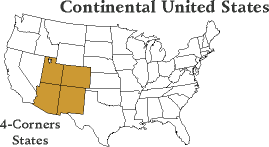
| Follow along with our explorers as they drive their custom expedition vehicle along the ancient routes of the Native Americans and the early explorers and pioneers through the American Southwest. The team spent four weeks in the fall of 2001 traveling in our specially equipped expedition vehicle, exploring the states that make up the "Four Corners Region" of the Southwest. |
|
Footsteps Journal |
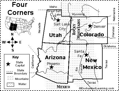
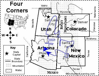
Click on a map to see it in detail
|
|
Lend a Helping Hand You can help make the Virtual Classroom available to students by making a donation today. |
|
The geography of the Southwest is mainly comprised of the Colorado Plateau, which is surrounded by mountains and deserts (see the Flora & Fauna section for desert information.)
The Colorado Plateau is actually a series of plateaus between 5,000 & 8,000 feet (1,500 & 2,400 meters) in elevation, separated by deep canyons. The plateaus are not really flat but rather topped by buttes, mesas and other topographical features that give the landscape its distinctive character. Erosion has also played a major role in sculpting the landscape, providing natural arches, bridges, spires and towers. To the southwest, Arizona’s terrain drops from the 2,000 ft (600 mt) Mogollon (pronounced mug-ee-own) Rim down to the Arizona-Sonora Desert. To the southeast, in New Mexico lie the Rocky Mountains. To the northwest in Utah is the Great Basin Desert. In the northeastern corner of Utah are once again the Rocky Mountains. This region includes the unusual Uinta Mountains, one of the few U.S. mountain ranges that run from west to east. To the northeast of the Plateau in southwestern Colorado are the San Juan Mountains and further east are the Eastern Plains and the lowest elevation in Colorado at 3,400 ft (1,020 mt.) The climates in the four states that comprise the "four corners region" range from some of the hottest spots in the country to some of the coldest. The climate depends mainly on the elevation and the topography and these four states contain some of the lowest deserts and highest mountains in the country. Traveling in these areas in the Spring and Fall can be quite a challenge because you never know when you might be hit with a sudden snowfall, rainstorm or extreme change in temperature. The average daytime temperature in Denver, Colorado during the winter is 42 degrees F (7 degrees C) and 86 degrees F (30 degrees C) in the summer. Whereas in Phoenix, Arizona the average temperature during the day in the winter is 68 degrees F (18 degrees C) and 105 degrees F (40 degrees C) in the summer. What is the weather like today in the American Southwest? Follow this link for the weather. Try converting the temperature in your town from Fahrenheit to Celsius. What time is it in the Four Corners Region as compared to the time in your home town? Check this! |
|
|
|
|
The Ancestral Puebloan people inhabited the Four Corners area of the Southwest. They are believed to have been the original inhabitants of what are now the Hopi villages of Walpi and Old Oraibi in Arizona and the village of Acoma in New Mexico. These three villages have the distinction of being the oldest continuously occupied villages in North America, all inhabited since the 1100’s. In addition they left behind many large villages, the ruins of which, archaeologists study today.
Many of the tribes living in the Southwest today are relatively recent arrivals. Beginning in the 14th Century, groups began to move into the areas that had been abandoned by the more ancient cultures. The Navajo, Apache and Utes were some of the new tribes. These new- comers were not conquers, but rather they all lived relatively peacefully with the Hopi and the Pueblo tribes. It was the arrival of the Spanish and later the Anglo-Americans that wrought the greatest changes on the Indian cultures. The Arrival of the Spanish In 1540 Francisco Vasquez de Coronado traveled from Mexico City on his failed search of the fabled "Seven Cities of Cibola". This was not a journey of exploration, but rather a search for riches to be plundered and brought back to Spain. Coronado brought the Spanish distain for native cultures to the Southwest, attacking pueblos and killing Indians. In 1598 a large group of Spanish and Mexicans, settlers led by Juan de Oñate, arrived in the Southwest, claiming the land for Spain and naming it New Mexico. The route they took from Mexico City become known as El Camino Real, the royal road. Again the Spanish, led by Oñate, treated the Indians poorly. The Spanish met any resistance on the part of the Indians with ruthlessness. Indians were beaten, killed, taken as slaves or cruelly punished by amputation of a foot. By 1608 Spain replaced Oñate with a new governor. The new governor, Pedro de Peralta, founded the city of Santa Fe as his capital. Santa Fe remains the capital of New Mexico today and it holds the title of oldest capital in the United States. In comparison, the British established their first colony in North America at Jamestown, Virginia in 1607. The Pilgrims arrived at Plymouth, Massachusetts in 1620. In 1675 the Spanish attempted to completely subjugate the Indians by destroying all their religious and ceremonial objects. In response, the Hopi united all the various tribes and in 1680 kicked the Spanish out of New Mexico in what became known as the Pueblo Revolt. This was an amazing feat as all the tribes spoke different languages. After the revolt, the differences between the tribes caused the unity to weaken permitting the Spanish to reclaim control in 1692. Another factor in the conquest of the Indian tribes was an unintentional form of biological warfare. The Europeans brought with them diseases to which the Indians had no resistance and which caused terrible epidemics within the tribes. By some estimates, 80% of Native Americans died from disease in the 16th to 19th centuries. The Anglo-Americans Following the Louisiana Purchase in 1803, the Southwest now abutted territory of the USA. Explorers and traders traveled to Santa Fe but were not welcomed by the Spanish. Most were arrested and had their merchandise confiscated. But when Mexico became independent from Spain, trade was encouraged with the USA. The Santa Fe Trail was established and American pioneers began migrating westward. Following the Mexican-American War in 1846, Mexico gave all lands between Texas and the Pacific Ocean to the USA. In 1853 the Gadsden Purchase bought an additional 30,000 square miles in southern Arizona and New Mexico from Mexico. Major trails crossed the Southwest in the 1800’s. The Santa Fe Trail linked Missouri with Santa Fe, the Old Spanish Trail from Santa Fe to Los Angeles and the Mormon Trail to Salt Lake City. Transcontinental rail lines brought a flood of people to the west. The first rail line was completed through northern Utah in 1869, with subsequent lines through Santa Fe and Albuquerque. Life for the Indians did not improve as Americans came to the Southwest, in many ways it became even more difficult. Whole tribes were forcibly moved off their traditional homelands. Those that resisted were often killed. In 1864 the military, led by Kit Carson, forcibly relocated the Navajos. Crops and homes were destroyed until the Navajos surrendered. Nine thousand Navajos were then marched 400 miles to a camp near Fort Sumner, New Mexico. The Navajos call this The Long Walk. By the time they were allowed to return home 4 years later, over 2,000 Navajos had died. Today, the Navajo Nation is the largest tribe in the USA and the reservation covers over 20,000 square miles of the Four Corners Region. Despite the failure of relocation, the USA continued its practice of cultural integration. Some Indian children were removed from the tribes and raised by white families. Education was provided by means of boarding schools where children had to leave the reservations if they wanted any form of advanced education. This practice continued through the 1950’s. Indians were not granted US citizenship until 1924 and were not given voting rights until 1948 in Arizona and New Mexico, and 1957 in Utah. In WWII Navajo and Hopi members of the Marines Corp. developed top-secret codes based on their languages. These codes were indispensable in the war against the Japanese. The codes were never broken. Today, the many Indian tribes across the USA are struggling to preserve their culture against the loss of traditions among their children. |
|
|
|
|
|
|
It is not really known when or for how long people have lived in the canyons and plateaus of the Southwest. Stone spear points embedded in the bones of extinct mammals were found in the 1920’s. These bones were dated to over 11,000 years old. Known as "Clovis Points" after the town in New Mexico where they were found, these spear points represent the earliest evidence of the first inhabitants of the Southwest.
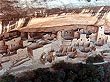
Archaeologists believe that there were several groups or cultures living in the Southwest by the year 100 A.D. The main groups were the Hohokam, the Mogollon and the Ancestral Puebloans. Another group that lived in the canyons of the Colorado River in what is now Utah were the Fremont. The Hohokam lived in the central and southern deserts of Arizona for nearly 2000 years, disappearing in the middle of the 15th century. They created an advance irrigation system along the Gila, Salt and Verde Rivers. Some of the canals where many miles long and up to 15 feet deep, and they were dug with only stone tools! The Mogollon (mug-ee-own) ranged from central and eastern Arizona through the southern half of New Mexico. Archeologists believe there are indications that this group merged with the Ancestral Puebloan culture by the 14th century. The Ancestral Puebloan culture inhabited the Four Corners area of the Southwest. This group is best known for the wealth of archaeological sites and cliff dwellings left as reminders of their passage. This is the culture that has been referred to as the Anasazi. This name is a Navajo term meaning enemy ancestors, so the more accurate term Ancestral Puebloan is now used. It is believed that, due to a combination of factors including a prolong period of drought, these people were forced to migrate from the Four Corners Region to the area along the Rio Grande River in New Mexico. Most of the evidence of these early cultures exist only on the ground in the form of pre-historic relics, artifacts and ruins. Take a minute and read what you should do when you visit archaeological sites. |
|
|
|
|
Ethnic Groups and Culture |
By 100 AD, three dominant cultures had emerged in the Southwest: The Hohokam of the desert, the Mogollon of the central mountains and valleys and the Ancestral Puebloans of the northern plateaus. In addition there were several other groups that were offshoots from the three main cultures. None of them existed in isolation however, and much blending of cultures took place. But by the mid-15th century however, most of these cultures had disappeared. The reasons for this have been the source of much discussion and controversy, but the generally accepted reasons include prolonged drought, climate changes, over-hunting and disease.
Today, many Native American tribes claim to be descendents of these ancient cultures. Today's Pima and Tohono O'odham claim to be descendents of the Hohokam. The Mogollon people were absorbed into the Ancestral Puebloans and their descendents can be found in the Pueblo Indian groups along the Rio Grande in New Mexico and in the Acoma, Zuni and Laguna Pueblos of New Mexico's northwestern corner. The most ancient surviving link with the Ancestral Puebloans are the Hopi tribe of northern Arizona. Here, perched on mesa tops can be found two of the three oldest continually inhabited villages in the North America, Old Oraibi and Walpi (Acoma in New Mexico is the third). These three villages have been inhabited since the 1100's. Read about the Hopi in detail, click here. Other modern tribes have descended from later arrivals like the Shoshone and Athapaskan tribes. Shoshone descendents include the Utes in Colorado, the Goshutes in western Utah and the Southern Paiutes in Utah and Arizona. Athapaskan descendents include the Navajo and a variety of Apache tribes. Read a story of Native Lore, The Legend of Spider Rock or Origin of the Clans. |
|
|
|
|
Fauna and Flora The Arizona-Sonora Desert |
What was once called the Great Southwestern Desert has been broken up into four distinct regions. Each has its own flora, fauna, climate and physical geography although some features are common to all four deserts as well as other areas.
The Arizona-Sonora Desert This desert covers most of southern Arizona and parts of California and Mexico. It is generally low-lying and hot with two rainy seasons, winter and summer. It is most characterized by the many varieties of cactus found there. It is especially known for the giant saguaro cactus that can be found nowhere else in the United States. Other cacti include organ-pipe, senita, prickly pear, barrel, fishhook, hedgehog and teddybear cholla. Trees can also be found there including the blue paloverde (the state tree of Arizona), the mexican paloverde, the ironwood and the mesquite. The two rainy seasons allow for two flower blooming seasons as well. Displays can be quite spectacular in particularly wet years. Commonly seen mammals include coyote, several species of rabbits and various species of ground, rock and antelope squirrels. Common birds are Gambel’s quail, the roadrunner and many species of hawks. Many species of lizards and snakes can also be found. The Chihuahua Desert This desert is found in southern New Mexico, the extreme eastern portion of Arizona and in parts of Texas and Mexico. It is generally higher in elevation than the Arizona-Sonora desert, therefore, it is cooler. Most of the rain falls in the summer. This desert’s most striking plants are the agaves and yuccas. The many varieties of agave sprout a flowering stalk that can rise as high as 15 feet (4.5 meters). This stalk can grow as much as a foot/day. This uses up so much energy from the plant that after flowering for a few weeks, the plant dies. Some yuccas resemble agaves with tall flower stalks, but others resemble shrubs. The main difference is that yuccas flower annually. There are 15 species of yucca in the Southwest and the soaptree yucca is New Mexico’s state flower. Other common plants include the creosote bush and the ocotillo. Commonly seen mammals include javelina (which look like wild pigs) and coati (a member of the raccoon family). The Mojave Desert This desert covers only a small portion of the northwest of Arizona and the southeast of Utah with the bulk of it in Nevada and California. The Mojave is the smallest, driest and hottest of the country’s deserts. In Arizona and Utah the elevations are slightly higher than in California and Nevada and the dominant plants are the eerie Joshua trees. These 30-40 foot-high plants are believed to live as long as 1,000 years. After a winter with heavy rainfall, the desert can be carpeted with about 250 species of flowers, 80% of which are endemic to the Mojave desert. The Great Basin Desert This is the continent’s most northerly desert and it covers western Utah, the Colorado Plateau and parts of Nevada, Oregon and Idaho. This is generally a high desert with most elevations above the 4,000 ft level (1,200 meters). This level of elevation brings less wildlife, and flora such as saltbrush and sagebrush cover the landscape. The most common animal is the rabbit although pronghorn antelope may also be seen browsing in the sagebrush. The sage grouse is a common bird, but the sage sparrow and sage thrasher are small and difficult to find. Grasslands once covered extensive areas of the Southwest, particularly in the river basins of Arizona and New Mexico. When cattle and sheep were introduced into these areas in the late 1800’s, the areas were quickly overgrazed and thus became extensions of the deserts. Today grasslands can be found in northeastern New Mexico and central Arizona. In these areas you can spot prairie dogs and small herds of pronghorn. East of the Rockies in Colorado are the Great Plains which are an immense grasslands, with dense forests of willows and cottonwoods along the major rivers. Buffalo (or bison) still exist here but in limited numbers. They were hunted to near extinction in the late 1800’s. The mountainous zones of the Southwest bring a surprising change and variety of flora and fauna. Between 4,500-6,500 feet of elevation (1,350-1,950 meters) you can find evergreen trees such as junipers and pinyon pines. Between 6,500-8,000 feet (1,950-2,400 meters) there are ponderosa pine, Gambel’s oak and various shrubs. There are fewer species of reptiles here, but squirrels and chipmunks are common. There are also mule deer, white-tailed deer, black bear, mountain lion and elk. From 8,000-9,500 feet (2,400-2,850 meters) the predominant trees are Douglas firs and aspens. Other trees include white fir and juniper. From 9,500-11,500 feet (2,850-3,450 meters) you find Englemann spruce, sub-alpine fir and bristlecone pine. This area receives heavy snow in the winter and mammals such as the Rocky Mountain elk and bighorn sheep are found here only in the summer months. The tree line begins at about 11,500 feet and the zone above the tree line is called the Alpine Zone. There are only a few areas in the Southwest that reach these elevations and here you find small tundra-like plants. Snakes, lizards and insects Several species of snake make their homes in the Southwest. These include the non-poisonous varieties of garter and king snakes. The poisonous variety includes several species of rattlesnakes and the Arizona coral snake. This can be found from central Arizona to southwestern New Mexico. There are also several varieties of lizard with the Gila Monster being the most fascinating. This large, slow lizard is one of only two poisonous lizards in the world. And although a bite can be fatal, it is very difficult to get bitten. You practically have to force it to bite you. About 20 species of scorpions are found throughout the Southwest. Their sting can be very painful, but it is not usually fatal. Centipedes can also bite causing a painful wound. The most dangerous spider in the Southwest is the black widow spider. Bites are very painful but rarely fatal. The brown spider also has a painful bite. The scary looking tarantula is not really that scary. They hardly ever bite and the bites are not serious (although they also can be painful.) There are over a dozen species of tarantula in the Southwest. See pictures of the animals and plants that live in the Southwest. Check these links: Desert Animals & Wildlife, AZ Fish & Game Photo Gallery |
|
|
|
|
Water has been a major issue in the Southwest for as long as there have been people. The most important river is the Colorado River and other major watercourses include the Salt, Gila, Green and Little Colorado rivers.
Early settlers had difficulty controlling the rivers for their own purposes. During the dry season the rivers would slow to a trickle or dry up completely and then they would be subjected to heavy summer downpours that would fill and sometimes overflow the banks. During the late 1800’s and early 1900’s settlers throughout the Southwest attempted to build dams to control and divert the waters for irrigation. Time after time the dams were swept away. It became clear to the government that if the Southwest was going to be successfully settled they would have to build federally funded dams. The first was the Theodore Roosevelt Dam on the Salt River in Arizona in 1911. Closely following were dams in Utah in 1913, New Mexico in 1916 and another in Arizona in 1929. Following the construction of these dams, there were constant arguments between the states as to who should be allowed to use the water. In 1922 Herbert Hoover brought the states together in the Colorado River Compact and engineered a scheme to divide up the water rights. The Compact laid the groundwork for a series of major dams on the Colorado River, particularly the Hoover Dam, built between 1931 and 1936, then the largest ever built and still the second highest in the USA. The arguments have not abated, however, and the search for more water continues. Recent additions to the Southwest’s water supply are underground water reserves, or aquifers. However, it has been determined that these aquifers are being "mined", that is, the water is being removed faster than it is being naturally replaced. Legislation has attempted to stop this "mining" before the aquifers are completely lost. Because of the current availability of water, cities in the Southwest have continued to grow. And more people require more water: a vicious cycle that has yet to be resolved. Water is a major issue in the desert areas inhabited by the various Indian Tribes. The Hopi and the Navajo are waging a grassroots project to educate their people about the scarcity of water in an effort to terminate the lease of the Peabody Mining Company to mine coal from the region named Black Mesa. The mining company uses millions of gallons of water to slurry the coal from the mine to the Navajo Power Plant. Be sure to read about the grassroots effort by the Tribes The Zuni are likewise pressing the federal government not to lease land in a historically rich area to the power companies that want to use an open pit mine that will divert millions of gallons of water away from the Puebloan People and their sacred sites. |
|
|
|
|
|
Contact us for information regarding sponsorship opportunities.
Join the Virtual Classroom. Complete the free registration form for your classroom today. Support the expeditions. Your donation will help to continue the research, documentation and Virtual Classroom web site presentation of these wonderful cultures and experiences to the broadest possible audience. To find out how you can help, please follow this link to our Helping Hand page. Thank you, now it's time to explore! |
|
Home The American Southwest |
Sources: Lonely Planet Publications, The Pueblo by Alfonso Ortiz, The Pueblos by Suzanne Powell
Kim and Don Greene, Authors; publication date October 1, 2001