July 5, 2005
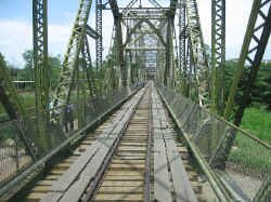
Leaving Gandoca late in the morning, we headed to the Panama border. It had been a couple of months since our last border crossing, so we mentally checked our list of things we needed for the crossing. The Sixaola crossing is a very quiet, laid-back crossing with very little traffic. Its main claim to fame, is that the bridge crossing the Sixaola River into Panama, is an old railroad bridge on which planks have been laid to allow cars to drive across it. It is also only one lane so one side has to wait for the other to finish crossing.
We arrived around 11:00am and were the only vehicle on the Costa Rica side waiting to cross. We finished our exit paperwork fairly quickly, but just as we were getting into our vehicle to drive across, two cars came from the Panama side. Oh well, we'll just have to wait. It took about fifteen minutes for the drivers the complete their paperwork and then it was our turn. We pulled slowly up to the bridge and eased our way onto the planks. Moving across, we attempted to miss the holes that occurred when the planks were moved or missing and we also tried to stay centered on the narrow bridge and not rub our tires on the rails that still ran down the center. It was a little nerve-wracking but overall it was uneventful.
Arriving on the Panama side, we discovered that it was an hour later, and the immigration officials were at lunch. Fortunately they re-opened within a couple of minutes of our arrival, however, there was a long line of people who had crossed from Costa Rica during the hour that Panama was closed. So, Kim got in line at immigration and Don went to the customs office to get our paperwork completed for the vehicle. As it turned out, Don finished just as Kim got to the head of the line, so the timing was perfect. But our truck sat on that one lane bridge for about 45 minutes because we couldn't move it off until we were allowed in the country. Sorry for the wait guys, but we don't make the rules.
Leaving the border area, we continued southeast along the coast. Most people who travel along this coastline visit the off-shore islands of Bocas del Toro, we chose to skip these islands as our time in Panama is short - we have to be in Panama City to complete our paperwork on July 11th so we can catch our ship. If we have the time, we plan to fly out to the San Blas Islands in the far south of the country.
This part of Panama was absolutely beautiful and we passed several waterfalls along the side of the road. The road was quite mountainous and steep and at times the vehicle was only going 10-12 miles per hour. Fortunately we didn't have terribly far to go before our planned stop for the night. We found a fabulous place to camp for the night alongside a river at a place called Willie Mazu Rancho Ecologico. This was a beautiful spot below the road, where we saw a bay-headed tanager (red head, green wings and blue body), which is a new bird for us.
July 6, 2005
The next morning we headed inland over the mountains toward the city of Boquete. The drive again was quite beautiful and there was very little traffic. Crossing over the Continental Divide, we drove over the dam at Lago Fortuna. This is a large lake that provides much of the hydro-electric power for the country, but it was almost empty at it appeared that men we working on some type of repair. We passed through jungle and pine forests, through clouds and bright sun. We found a new road that wasn't on the map and got to experience a sense of adventure by navigating by compass when there were no signs.
We arrived in the lovely town of Boquete just in time for lunch. Nestled in a valley on the flank of Panama's tallest mountain and only volcano, Volcan Baru, Boquete is known throughout Panama for its cool climate and natural setting. It is also the jumping off point for Panama's best river rafting, on the Rio Chiriqui and the Rio Chiriqui Viejo. We spent some time making arrangements for tomorrow and then we took a drive around a loop north of the city. Along the way we passed waterfalls, coffee plantations, fruit farms and ranchitos belonging to the local indigenous group, the Ngobe Bugle. In the 1500's, the Spanish arrived and attempted to placate and convert the local tribes. Unfortunately, measles also arrived with the Spanish and of the 10 or more tribes that had inhabited the area previously, only the Ngobe Bugle survived. Today they live on a large reservation in the Chiriqui highlands and are seeking statehood.
July 7, 2005
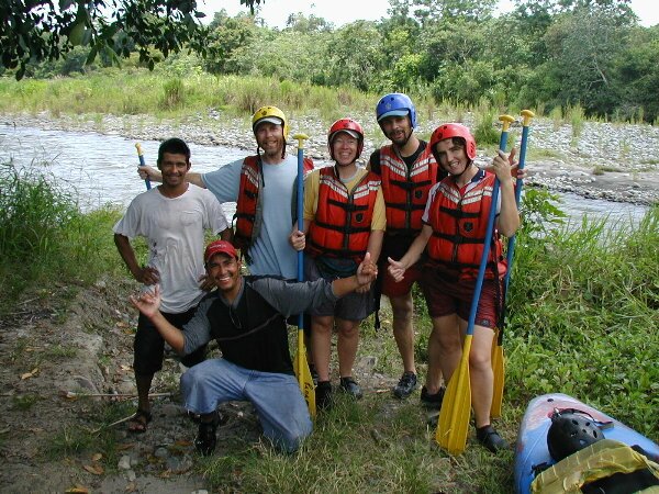
| Today we went river rafting on the Chiriqui Viejo. We joined with two other people and set off in a 14 foot raft to conquer the class II & III rapids. We were given instructions on how to paddle and we practiced following our boatman's instructions. Our boatman, Jorge, was quite a clown and was always doing his best to make sure we were absolutely soaked in every rapid. He also pointed out a couple of iguanas lounging in a tree and a number of birds such as cormorants, herons and kingfishers. Nobody fell out of our boat, even though some of the rapids were pretty rough and we all had a great time. |
|