|
Jan 24 - 29, 2006 - La Cuarenta
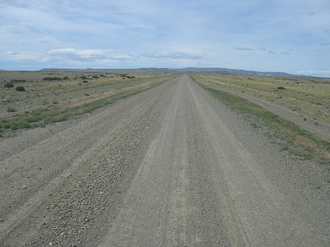
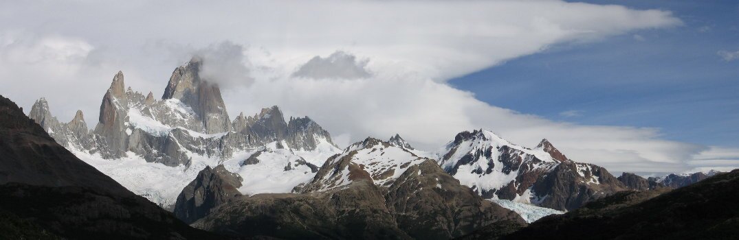
Outside of El Calafate, road crews are working on eventually paving all of Route 40. But in this area the road was just ripped apart and the high winds were blowing dust for miles. Visibility was terrible and the winds coming off Lake Argentino were ferocious. We slowed down to 10 miles per hour and continued down the road, trying to stay out of the way of oncoming traffic and the rocks they were likely to throw up at our windshield. We were finally able to stop for lunch at about 3pm when we were able to find a small building to hide behind. Without some shelter, it is very difficult to get out of the car. It really takes two people, one to hold the door open, so it doesn't slam on the other person while they climb out. About 4pm, we found some pavement already completed and were able to sail into the Fitz Roy sector of the Parque Nacional Los Glaciares. For some reason the last 10km (6mi) isn't yet paved, but you would hardly notice it for the view. It was absolutely incredible. Pulling into town, we passed up the first campground, as it was very unprotected from the wind. Crossing all the way across town, we discovered that the entrance to the next campground was too low for us to pass under. Aargh. Driving down the road that passes out of town, we discovered a parking area adjacent to the campground that had a spot just right for us. With a very nice view to boot. That night the wind actually died down, but we didn't know what to expect for the next day when we wanted to hike to Cerro Fitz Roy. Especially since the forecast was for clouds and 45mph gusts. We awoke the next morning to blue skies and calm winds. Keeping our fingers crossed, we set out on an all day hike prepared for everything from a heat wave to a snow storm. In Patagonia, you never know what will happen as the weather can change in the blink of an eye. Our hike began with a very steep ascent and we were reminded once again how out of shape we are. And with the bright sunshine and no wind, it was quite warm. When we finally reached the plateau section of the hike, we were sweating buckets. We sat down to rest and enjoy the incredible views. When we had cooled down, it was time for our first clothing change as our sweaty clothing soon grew cool. We changed into long sleeve thermal shirts and continued our hike. Throughout the rest of the day we would go back and forth with putting a jacket on as well. By lunch time, we had reached the campground at the base of Cerro Fitz Roy. We had been surprised by the number of hikers on the trail, but we were truly amazed at the number of tents in the campground. Especially since the number of cars on the road had been so small. Where did all these people come from? Anyway, by the time we reached the campground, we were already feeling tired and sore, so we knew we wouldn't be making the steep final ascent to the cerro. This stretch rises over 1,200 feet in about one mile. But we didn't feel disappointed. The views along the way were so magnificent that we didn't feel we would be cheated by not climbing the final section. We enjoyed our lunch and then hiked up the small river canyon next to the main trail. We were able to see other people trudging up the mountain and were glad we had made the decision we had.
The hike to the campground had taken us about 3-1/2 hours and we knew we would need at least that much time to get back. We started back at about 1:30pm and enjoyed the different views on the way down. All day long we had been marveling at the beautiful weather, especially in light of the forecast, so I guess we shouldn't have been surprised by the numbers of people still coming up late in the afternoon. Everyone wanted to take advantage of the beautiful day and we also reminded ourselves that it does stay light until 10pm. We finally made it back to our camp by about 5:30pm and boy were we beat. The final descent was quite a killer and our legs and knees were sore and tired by the time we finished. We checked our GPS at the end and discovered we had hiked almost nine miles! That night the winds kicked up again and we spent the night rocking and rolling. The next day we were back on the road, high winds and all. We saw very little traffic and a lot of guanacos and rheas. In this part of the country the rheas are called the nandu. The rheas all had lots of babies, 12 or more, to tend to and it was fun to watch them. The not-so-fun part of the road was the constant need to watch for large rocks and washboard road. We didn't want to get any flat tires or shake anything loose on the truck. As much as we wanted to, we knew that we wouldn't be able to wild camp without some kind of protection from the wind. So using our guidebook, we were able to find an estancia that had trees to block the wind. The kind people at La Angostura even let us park on their property for free, since we didn't use any of their services. The next day the winds continued and the number of estancias along the road dwindled. We were now on the part of the road that sees the least number of people and has even less services. Like none. Considering the high winds, it wasn't surprising that the number of people living out there was limited. There are very few areas to get out of the wind and you would need to find the right combination of a water source and wind protection to be able to survive. Toward the end of the day, when we were getting close to the UNESCO site La Cueva de las Manos, we were suddenly passed by 10, count 'em, 10 Ecuadorean 4x4 vehicles. They were all outfitted with roof top tents and had stickers on them like they were part of some sort of rally. I'm sure they were having a great time as they zoomed past us, but all we got out of the bargain was a lot of dust. And when we reached the cave, we discovered that they had taken up a large part of the available parking and we were unable to turn around to park. So we decided that we would find a spot to camp for the night and visit the cave the next morning. We drove back out the way we came and discovered a fine spot, not really out of the wind, but out of the way of the flying dust all those cars were going to kick up when they left. Later on that evening (after all the traffic had subsided), the wind died down and we were able to take a hike up the nearest hill and enjoy the beautiful views and the nice sunset. The next morning we headed back to the cave and were able to catch the first tour of the day. You are only allowed access with a guide as, unfortunately, people over the years have vandalized the pictographs. La Cueva de las Manos means the cave of the hands and there are more than 800 hands depicted in the cave in the colors of red, black, yellow and some green. There are other paintings as well, including geometric figures and people hunting guanacos. The oldest paintings date back to 7000 BC. After visiting the cave, we headed back out onto the road. From here the scenery changed, and there were more mountains and streams. We also drove through an area of "badlands" where the minerals in the soil were very close to the surface and were very colorful. There was a lot of dust in the air which we later were told was actually volcanic ash from an eruption that occurred in 1991 just across the border in Chile. Toward the end of the day we turned off to go to another estancia for the night, this one called Estancia Telken. The estancia dates from 1915 and is also a working sheep ranch as well as a guesthouse. We decided to have dinner with the owners and other guests and had a very enjoyable evening chatting and learning about the history of the ranch. They told us about the volcanic eruption and indicated that the falling ash covered the ground, in some places over a meter thick, and killed many of the estancia's sheep. The owners were now awaiting a new shipment of sheep that had been purchased with the help of the government (better late than never). In the morning, we were able to watch as the new sheep were delivered to the ranch. We helped count as the sheep came off the truck and counted over 800 new sheep being delivered. In the afternoon we drove the remaining miles to the Chilean border at Los Antiguos where we stocked up on a few supplies. We'll cross into Chile and begin our drive on the Carretera Austral, the famous road that opened up Chile's Patagonia to settlement.
|