WESTERN SAHARA, MOROCCO
November 19-21, 2008
Our drive across Western Sahara (a disputed area of land claimed by Morocco) lasted for four days. We didn’t exactly take our time, but we didn’t rush either. We enjoyed our morning walks (usually along the coastline) and one day we actually stopped and spent a day doing chores (like laundry).
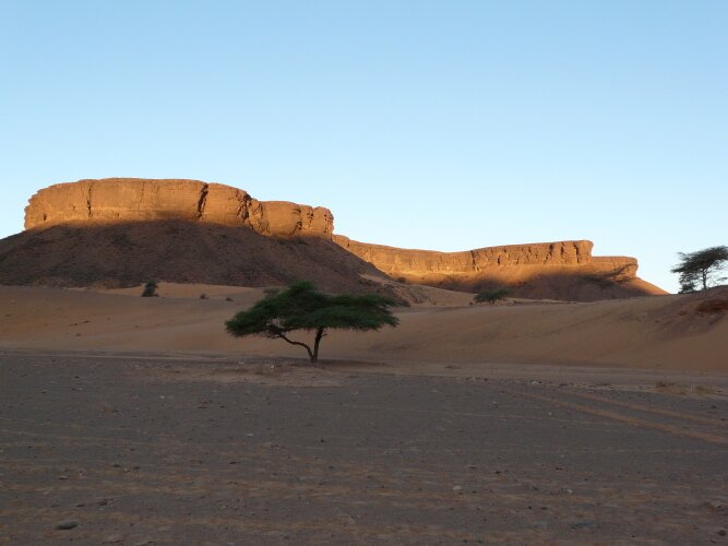
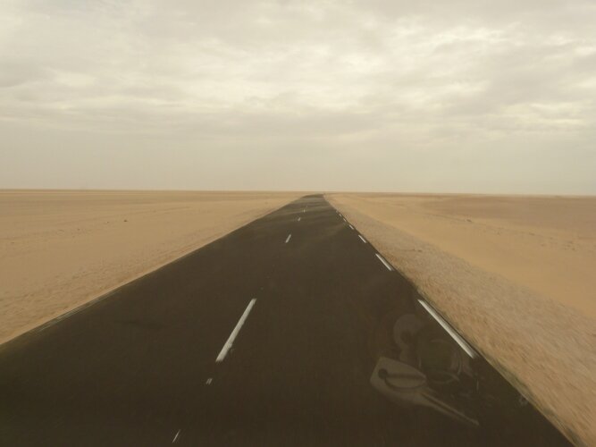
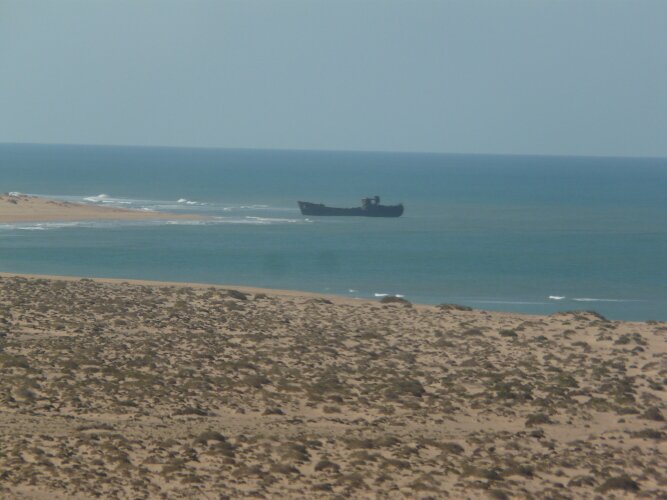
Western Sahara is a stark desert landscape where the road runs parallel to the Atlantic Ocean. On the beach we could see several shipwrecks and our guidebook indicated that most likely the ships had been intentionally run aground for insurance purposes. The road through the desert and along the cliffs is narrow in spots and care must be taken when other cars are passing. There are also spots where blowing sand has covered the road. Oh yeah, and be sure to watch for camels crossing the road.
|
|
|
Most days we were able to find lunch spots and camp overnight, right on the ocean. Our wild camp spots were silent and serene with no interruptions from people, music or barking dogs. Before venturing into the desert we stopped in the town of Layounne and did some errands. In addition to grocery shopping and internet duties, we had lunch out and had a great seafood mix lunch which included bread, french fries and olives for less than $5.00us.
MAURITANIA
November 22, 2008
Last night we found a great camp spot on the bay across from the last town on the Western Sahara - Dakhla. As we watched the sun set we enjoyed the way the light reflected on the huge sand dunes that bordered the shore. Today we arrived at the Mauritania border at about 3:30 in the afternoon. As we debated whether to cross or make camp and cross in the morning we met a couple traveling on a motorcycle and we all decided to cross together.
The first stumbling block was how long it took to get signed out of Morocco. It took over an hour just to get our passports stamped out. We don’t know what they were doing with them, but we had no choice but to wait.
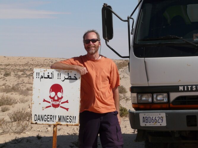
We then entered the No Man’s Land between Morocco and Mauritania where there is no control and no maintenance (and no road). You have to find your way to the border post by luck. Oh yes, to add to the fun, this border is disputed between the two countries and the area is allegedly full of mines!
|
|
We had some GPS points to follow, but the person who recorded them must have had a smaller vehicle and been in a big hurry, because the route they took was direct but through very soft sand. We headed through a soft spot but came to a halt pretty quickly. Kim jumped out and turned the locking hubs to 4X4 and pretty soon we were on our way. Not so the motorcycle. Down they went and Don jumped out to help them lift their heavily laden moto. |
After that we tried to choose our paths a little more carefully, but there were a couple more difficult spots. Finally, we could see the border post up ahead. Arriving at about 5:30, we wondered if we would be able to cross before the border closed at 6:00 (according to our guidebook).
There was a gate just prior to arriving at the Mauritanian offices and it appeared that no one could enter the gate and start the passport/vehicle clearance without their vehicle. So we waited our turn and began to chat with the driver in front of us. Rahim informed us that the border does not close at 6:00 and that everyone would get through.
Finally our turn came. We were allowed in and directed to a parking spot. A border official came out and requested to search the vehicle. This was not unexpected, so we allowed the officer to do his search. We don’t know exactly what they were looking for but we do know that it is illegal to bring alcohol into this Muslim country, so certainly that was high on their list.
After their search was completed, we were directed to the office of the Army who wrote down all of our pertinent information. We were then directed to passport control where our passports were stamped. We were then sent a little further down the road to the customs office where our Carnet was stamped for a fee of 10 Euros (no arguing this, you can pay it and go or not pay it and not go.)
Finally, after a total of 3-1/2 hours (a new record for us) we were on the road with our new friends Mark and Allison. (We found out later that other travelers had taken as long as 5 -1/2 hours to cross) It was now 6:30 and very quickly getting very dark. We hurried down the road, but soon realized that speed was not our friend when we hit a huge pothole at a very uncomfortable speed. We slowed down and headed into the nearest town of Nouadhibou. The town is very long, and of course the campgrounds are at the furthest end. We finally found the one we were looking for but it turned out to be closed due to renovation. But fortunately there was another one right around the corner. Chez Abba turned out to be large and quiet and soon we were set up for the night. It was now 8:00 as we headed out for dinner and we found an Asian restaurant close by that served up some really tasty food. Welcome to Mauritania.
November 23, 2008
We spent the next day checking out the four ATMs in town, none of which would take foreign bankcards. We then had to find someone to change money for us. This was actually really easy as the campground owner had a "friend" who could do this for us, and they even changed some of our American currency (Euros are preferred). We also had to check out purchasing vehicle insurance, which is required.
We then talked to some people in a different campground about their intended routes. Everyone seemed to be undecided about where they wanted to go and we all spent time discussing options. Finally in the afternoon we went to the central market and bought ingredients for a big dinner with Mark and Allison.
November 24, 2008
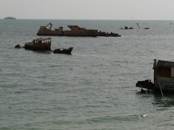
| We ran some errands in the morning and headed out of town shortly before noon. First we headed further south onto the peninsula where Nouadhibou is located so we could check out the boat graveyard. Legend has it that the boats were scuttled for insurance money and there sure are a lot of them, filling the harbor and, I would imagine, making legitimate shipping travel very hazardous. |
|
|
|
We then headed north and out of Nouadhibou. We found a nice spot on the ocean for lunch and when we looked along the coast, we saw…flamingoes! These were greater flamingoes, the larger of the two species found in West Africa, and quite beautiful. |
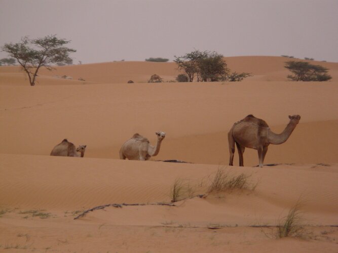
We then set off south for the capital city of Nouakchott where we had heard there was an ATM that would work with foreign cards. It is a long journey down a new highway along the western coast of Mauritania with absolutely nothing in between. We did however see several large herds of camels. We stopped for the night behind some dunes and made our first wild camp in West Africa. Before this road was built, the only way down nearly 300 miles of the country was by driving along the beach!
|
|
|
November 25, 2008
We were awakened in the middle of the night to the sound of rain. In the Sahara? Apparently. But by morning the rain had stopped, even though it was still cloudy and we enjoyed our morning walk among the dunes. We even saw camel tracks going around both sides of the Fuso that hadn’t been there the previous evening, though we must have slept through their visit. We continued on our drive south to Nouakchott, arriving around noon.
We easily found a campground (on the correct side of the city) and stopped to ask for help finding the ATM. Not only did they give us a map to the one and only ATM that accepts foreign cards, they had WIFI! We were able to check our email and get updated on the news before heading off.
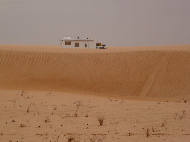
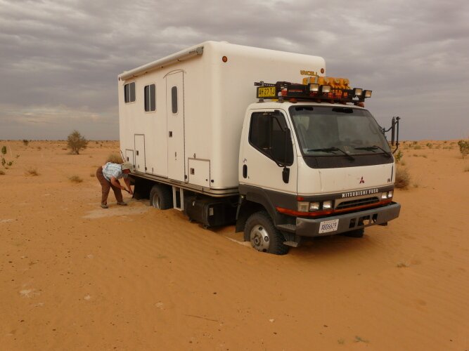
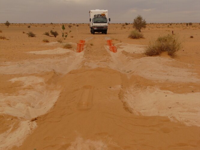
With our map, we easily found the ATM and soon were set to go. We headed off to the town of Atar, Mauritania’s one tourist destination. Also a long drive away, we once again stopped in some dunes for the night. But wait, adventure awaited us before we could make our final stop. We decided to drive across open ground before the dunes rose up. We made it about a quarter mile across before soft sand struck. Buried quite deeply, up to the differentials, we pulled out our MaxTrax and started digging. It took a little while (less than an hour) and we were finally free and back on firm ground. Another great story, stuck in the sand in the Sahara Desert!
|
|
|
November 26, 2008
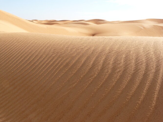
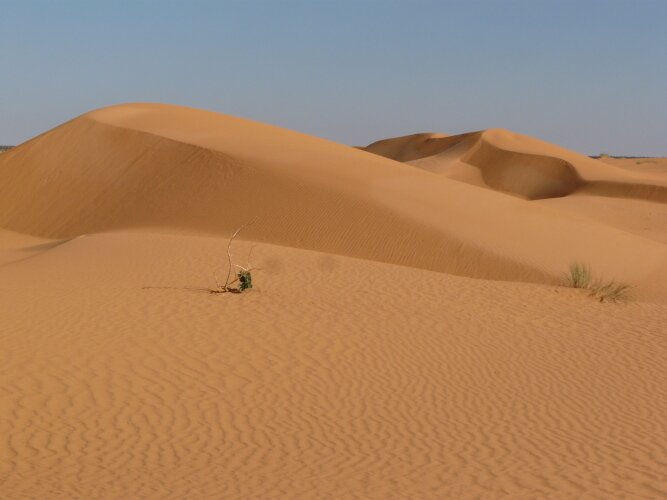
We spent a good portion of the morning wandering around in the apricot colored dunes that fronted us. The colors and the textures were beautiful and we had a great time taking photographs. We finally got on the road in the late morning.
|
|
|
Our lunch stop was off the road surrounded by camels and this was when we first noticed just how hot it was outside. This was our first day in quite a few that hadn’t been overcast so the heat sort of came as a surprise. At four in the afternoon it was 94 degrees F, 34 degrees C.
We turned off the main highway to visit the oasis village of Terjit. The road was very corrugated and we had to keep our speed down to about ten mph otherwise we’d be shaken and rattled like being in a blender. We parked our car on the outskirts and walked down the only road. The buildings appeared to be close to the road and we were concerned about getting ourselves stuck within the village. The villagers greeted us and the children asked us for cadeux (a gift). It was a pretty typical scene, one that will surely be repeated in each village.
| We wandered down the street, looking at the various crafts for sale and purchased some dates (the primary source of income in the town). We checked out a couple of camping spots, none of which was easily accessible with our big vehicle and decided to once again wild camp, this time a couple of miles down a side road outside of town alongside a very dry riverbed with camels and acacia trees for atmosphere. The location reminded us strongly of the American Southwest with its mesas, buttes and river canyons. |
|
November 27
After taking a short walk along the riverbed we returned to Fuso to make breakfast. As we were cleaning up three young people who were herding their goats decided to stop by. We attempted to make conversation with them in our rudimentary French, but they were more interested in just watching us. This has become known to us as "traveler TV’. We as the travelers become the TV that the locals watch. After all, they are just as interested in how we live our lives as we are of them. The difference is that they don’t feel that it might be intrusive to just stop right in front of you and stare. It’s a bit like being on display in a zoo. Our friends must have had enough as they only stayed about 10 minutes.
|
|
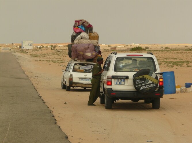
We retraced our bumpy way out of the canyon, onto the highway, through a couple of more police stops, to Atar. Oh, did we mention all the police, military and customs stops? We aren’t sure if the government just wants to keep tabs on all of the travelers in their country or if the stops are part of some massive public works program to put people to work. Nearly every village along the highway will have two stops, one manned by the police and the other by the military or customs officials. At these stops, we are asked for all the same information, passport, name, job, reason for visit, what country are we from, destination and a few other questions. As you can see, many of the vehicles are impossibly loaded with so much stuff that it was hard for us to imagine them being able to drive at all. |
A good thing that we learned from other travelers is to have a sheet of paper printed up with all of this information already written. This form is called a "fiche", and the officials generally accept a copy in lieu of looking at any original documents, and we can be on our way in just a minute or two - and most times we're even given a salute!
A funny side note here, it appears that everyone – from the police to the kid on the street, knows that Barack Obama has been elected President of the United States. When we answer their question about where we are from, we are greeted warmly, told that Barack Obama is #1 and given a thumbs up. Seems that this may be a great time to be an American traveling in the West Africa Islamic countries.