|
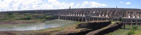
Dec 13-18, 2005 - Iguazu Falls We made it across Brazil today. Our final 1000 km (620+ miles) from Rio de Janeiro to Foz do Iguazu took us just over four days and cost us nearly $100us in tolls. Unlike in the north of the country, the southern highways are in pretty good condition, the catch is that we have to pay for them in the form of tolls. Our first stop was the Itaipu Dam, the largest hydroelectric power plant in the world. Built along the Paraguay/Brazil border on the Parana River just above the split with the Iguazu River and Falls. The Dam is 639 feet (196m) tall, 25,220 feet long (7760 m), and it currently provides for 90% of the power used in Paraguay and 25% of that in Brazil. The Dam corporation provides free tours of the dam, so of course we had to take one. We were driven in a bus first to get a close up view of the powerhouse and spillway, and then to our surprise the bus drove across the face of the dam then up on top and down the length of it. It really gave us a feel for the size of this beast.
Leaving the dam, we drove into the city of Foz do Iquazu (Iguazu Falls). The city is about 25km (15miles) from the entrance to the National Park and the falls. We found a campground just outside the park entrance, and as it turned out, right under the flight path of the tour helicopters and next to the airport. Lucky for us the flights stopped at sunset. In the campground we met our first other "overlanders", a couple from Italy driving their four wheel drive Iveco camper. The National Park doesn't permit private vehicles to drive to the falls, so we walked from our camp to the park entrance where we took a bus to the falls. The closer we got to the falls, the more excited we got as we started to get glimpses of the falls through the trees. We got out at the top of the falls to views of the wide river channel and the "smoke" that is really mist rising up from beyond the lip of the falls. The park provides really close access to the falls via a network of raised walkways built in the riverbed right along the edge of the falls! The views were just incredible, and we took a zillion photographs. We spent the next few hours walking the series of paths that go along the canyon's edge, stopping every few feet to see a new perspective of the falls. Depending on the time of year, the park claims to have nearly 270 falls along the Brazilian and Argentina sides of the canyon. Back at the campsite, we ended the day with some easy bird watching, adding several new interesting birds to our list. We added a new country to our experiences this morning, Argentina. The paperwork to release our car from the Brazil side was easy but time consuming. Once we crossed over to the Argentine side, however there was a HUGE line of cars waiting to cross. Uncertain what they were waiting for, and knowing that we needed to do paperwork, we drove up the shoulder to where a policeman was directing traffic. He directed us to where we needed to go and our paperwork took about ten minutes. I'm sure some of those cars in line are still waiting. The town on the Argentina side of the falls is called Puerto Iquazu and is a much smaller town than Foz do Iguazu. More attractive and easier to navigate as well. We were able to find an internet cafe, a bank, a grocery store, a restaurant and a campground all within two miles. It was a very pleasant little place. Our next stop was the Argentina side of Iguazu Falls. Everyone has their favorite side, so we were determined to see for ourselves which was better. Unfortunately when we arrived at the entrance we discovered that the most desirable area to explore in the park, the walkway to Garganta del Diablo (the devil's throat) and the best part of the falls, was closed. The walkway had been washed away in a flood several years ago and was in the process of being rebuilt. In recent years, boats had shuttled people to a still-existing portion, but that apparently was no longer the case. But we were told the new walkway would open "maybe tomorrow". This time access within the park was provided by a Disneyland-like train. Very slow (we later found we could walk the same distance faster), it brought us to the second best walkways from which we could get very close to the tops of the falls themselves. Very nice, but not as impressive as the Brazil side. Besides, it was hotter than heck. But one unexpected delight were the tremendous numbers of butterflies. Large ones, tiny ones, colorful ones, ones that looked like tree bark, some that were nearly psychedelic. They were really magnificent. So, because a second day ticket only costs half the price, we decided to return the next day to see if the walkway was open (yeah, right). The next morning on our way out of town, we stopped again to see if Garganta del Diablo was open. Miracle of miracles, it was! This was absolutely amazing, we rarely get this lucky! This walkway hasn't been open for years and we got to be there at its inaugural. But our usual luck held and we missed the train to the last station, so we walked the 2km trail to the walkway. The walkway was then another 1 km long and we were able to view the pieces of the old walkway strewn about in the river. We're not sure why they haven't removed them but it can't be because its too hazardous, they built a new walkway there. When we finally arrived at the viewpoint, the view was magnificent. I don't believe there are very many places where you can get as close to a tremendous waterfall as you can on this walkway. Worth the extra money, the extra drive and the extra walk.
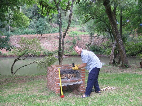
After leaving the falls, we continued our journey south driving through gorgeous countryside. We stopped in the late afternoon at a lovely private campground situated on a river. We spent an hour or so cooling off in the river and then decided to use one of the campgrounds BBQs to cook our dinner. Other people were kind enough to have left behind wood and even charcoal. Don used his master fire building skills and got a very nice fire going. After it burned down to coals, we threw on a couple of potatoes and our chicken. Everything was going splendidly and the chicken was almost done when suddenly we heard thunder. Uh oh. We waited a few minutes and the small drops started. Kim began moving supplies back to the Fuso and then it really started pouring. Don was able to take cover under an overhang until the chicken was done but he still got soaked getting back to the truck. We now joke that the best way to get moist chicken is to cook it in the rain! After an entire evening of rain, the next morning dawned clear and clean, except for our little stream which was now running quite a lovely shade of brown. Considering it would take 2 days to clear up, we felt lucky to have had our time there.
We then moved on the the less intact ruins at Loreto where we had lunch and then wandered through the quiet landscape having to use our imaginations to picture what was another large complex that was begun in 1660. We continued our adventure by striking out across mostly uninhabited land toward the Esteros del Ibera. This is a wetland covering 13,000 sq km that is recharged almost exclusively by rainwater. It is protected by the Ramsar Convention on Wetlands of International Importance. On our drive there we started seeing lots of birds and then more birds, so many birds we gave up trying to identify them. There were hawks and eagles, herons and egrets, storks, woodpeckers and kingfishers, not to mention the various flycatchers and on and on. We also saw our first greater rhea (a bird that is similar to an ostrich), a capybara (a large member of the rodent family almost the size of a pig!) and the area's two types of deer, the marsh deer and the pampas deer. We spent the night wild camped off the road in a grove of trees, next to a radio tower. It was a great spot with lots of privacy (and birds). The drive the next day was long, down an alternately sandy and muddy road (thank goodness for 4-wheel drive), but we were rewarded with seeing our first Argentine cowboys - Gauchos - in traditional garb (hat, wide belt and pants tucked in their boots, wide brimmed black hats and sitting on a sheep skin). When we finally arrived in town we were greeted by a tourist office with helpful information and a municipal campground located right on the lagoon. We were able to take our kayak out from there and do some more exploring. What a marvelous place. The next morning we met some lovely Argentinians from Buenos Aires with whom we chatted with for a little while. They were on vacation and really enjoying the area also. Its always interesting to meet new people and our experience so far has been that the Argentine people are very friendly and helpful. Then it was time to tackle the road back out. This road was actually in worse shape. No sand or mud, but very bumpy and rutted. About 2/3 of the way out we encountered a road grader so that helped for a while. When we finally got to the paved road it was a real relief, but this is only the beginning of our travels on dirt roads, so we'd better get used to it!
|