|
Sept 27, 2007
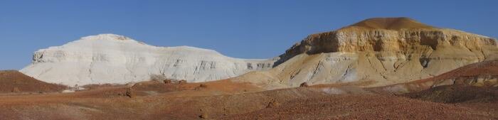
We started our day by driving into the state of South Australia. Our destination was Coober Pedy but we detoured into the desert to view the painted desert formations at The Breakaways and to do a couple of short hikes.
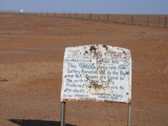
| We then stopped to examine the Vermin Proof Fence, which is otherwise known as the Dog Fence. The Dog Fence is the longest fence in the world, built by the Aussie sheep ranchers to protect their herds from the dingo. The sheep were easy prey for the dogs and they initially decimated the herds. At one time the fence ran for over 9,000km/5,600 miles, but is only about 2/3rd as long now. We made camp on the edge of a creek bed in the Moon Desert within sight of the fence for the night. |
|
Sept 28
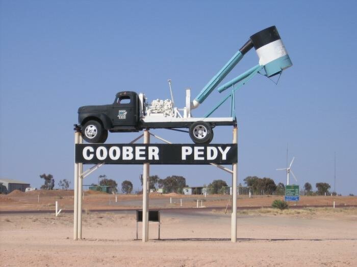
During the night we could see the lights of Coober Pedy off in the distance, yet it took us about an hour to make the corrugated drive into town. Along the way we could see thousands of the tailing mounds dumped by the miners in search of opals. Some 90 percent of the world's supply of opals comes from this region of Australia.
There really isn't much to the town, but we wanted to experience the other-worldliness feel that the town projects. The region is so inhospitable that film makers have come here when they need a place that could resemble either outer-space or a post-apocalyptic world - like for the Mad Max movies. The town is dry and dusty and because many of the buildings are underground, the color of the town just looks like the color of the surrounding landscape. Kind of a dull beige. Underground, you say? Read on...
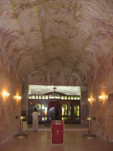
The opals are found underground and as the miners have dug for them, they have carved out underground homes to live in. With summer temperatures exceeding 45C/112F, below ground homes are very comfortable. We explored several of the buildings, underground businesses, hotels, homes and even churches. The rock underground is actually very pretty, having a rainbow-like sandstone appearance.
Since everyone is town is related in some way to the mining industry, everything in town is related to the mining industry. We saw trucks driving down the main drag with signs warning "explosives". We saw trucks with the most unbelievable equipment on the back, even an old bus that had been modified for mining. Even the hotels are underground to capitalize on the mining industry. But since you can't mine every hour of every day, there was even a golf course spread out over the dry, dirt plain. It was a very interesting/bizarre town.
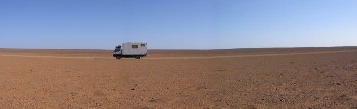
Heading off into the desert, we again found a creek bed with trees to shelter us as we made camp for the night. Yet getting here we drove through desert that was pretty much flat to the horizon and devoid of just about any living thing.
Sept 29
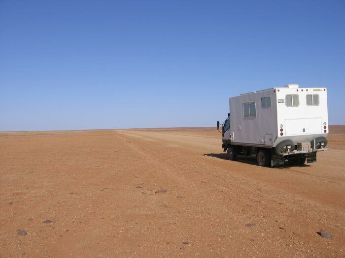
The thing about deserts is that they are not always barren, boring places. Yesterday we drove through flat nothingness, and today just a few miles down the track we found ourselves in beautiful red sand dunes. It was quite a drive. Along the way we drove through Anna Creek Station, the world's largest cattle ranch. At one time the ranch reached from here to the rail head near the ocean, some thousand square km/miles. The need for such large stations, as these ranches are called, is necessitated by the lack of water and feed for the animals.
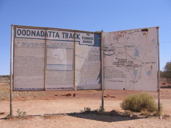
We stopped for lunch at the roadhouse at William Creek, supposedly in the middle of nowhere along the Oodnadatta Track. Driving through a remote area, which this region is claimed to be and where we have received dire warnings to be prepared and totally self-sufficient, we found ourselves getting passed by motorcycles and groups of 4x4 vehicles. Well, it turned out that this month is, once again, school holidays across AU so many families are out exploring. One popular way to explore is to join a "tag-along" tour. This way people can feel safe traveling across deserts in a convoy of vehicles to share the experience and have support if needed.
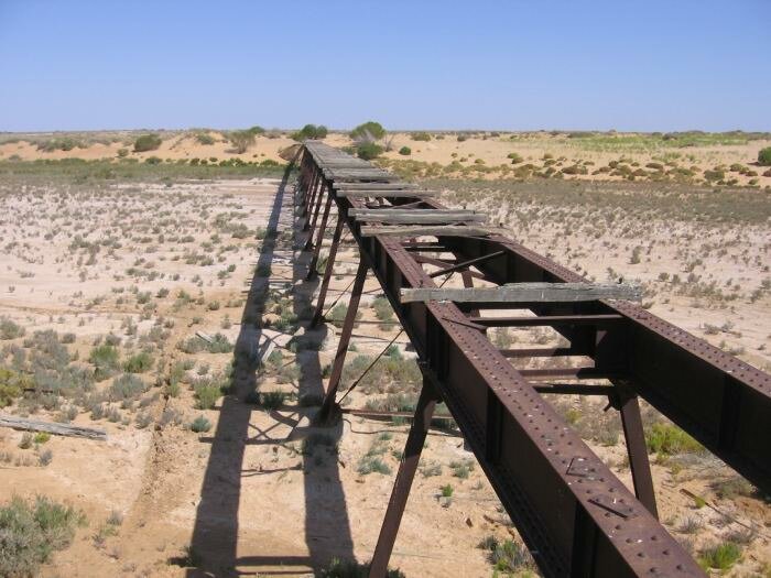
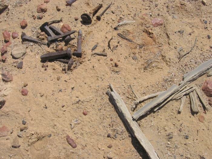
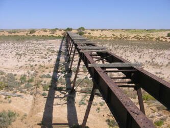
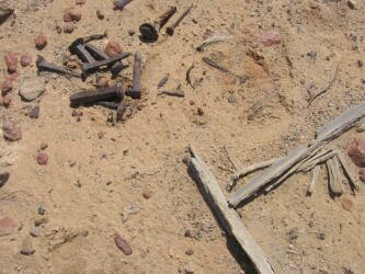
One of the attractions for us in driving the Oodnadatta Track is that it follows the old Ghan Railway - the original train line that crossed the desert, and the overland telegraph line, which connected Australia to the rest of the world. Surprisingly, the railway bed is in some places right next to the road, so we had opportunities to stop on explore the line. Although most of the track and wooden ties have been removed and recycled, we found many pieces of it still remaining. There were untold numbers of rail spikes lying around, broken RR ties and twisted pieces of metal rails. Even the bridges over long desert washes were still standing. As we wandered away from the RR line, we were even more surprised to find remnants of the telegraph line still existing. Again, most parts had been recycled, like the poles and insulators, but we did find twisted poles, broken insulators and even long runs of the telegraph line itself still around. It was amazing to be able to walk through over one hundred years of history.
|
|
|
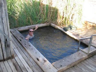
| We made camp at a spring with a "natural spa" that had originally been a train stop on the Ghan. The spa was a bore, what is also called a drilled well, that provided water for the steam engines. Over time the heavy amounts of minerals in the water rusted the lining and the water broke out of its containment and created a wetlands area in the middle of the desert. Oh yes, we did take advantage of the spa and relaxed in its bubbling water. |
|
Sept 30
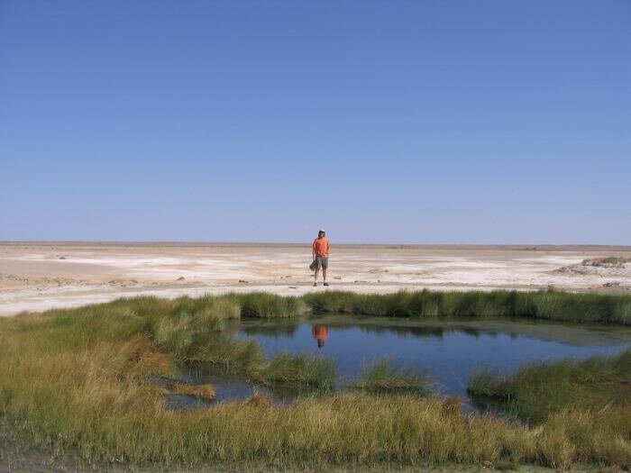
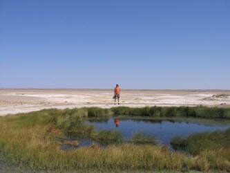
| In the morning we visited Wabma Kadarbu Mound Springs Conservation Park, created to protect the local mound springs. Mound springs are created when underground water finds a weak spot in the ground and pushes upward. The water dissolves lots of minerals out of the rocks and salts and sediments collect around the edge of the spring, forming a mound with water in the center. Additionally, unique ecosystems have developed in and around the springs. These include small crustaceans, small fish and freshwater snails and some are found nowhere else on the planet. It is a completely unique phenomenon of this area and an amazing sight to see in the middle of the otherwise dry, featureless desert. The two springs that we visited, Blanche Cup and Bubbler, were quite large, and Bubbler had such clear water that you could see the sediment erupt and settle when water was forced up through it. |
|
Continuing our drive, we passed South Lake Eyre which most of the time is a large dry lake bed. Only in extremely wet years does the lake hold water and in 1974 the lake was filled to capacity, disrupting both the rail line and the road. We also passed a "sculpture park" where an individual has constructed huge, weird metal sculptures over a large area of desert. We made camp at the site of more ochre deposits still used by Aboriginals to make body paints for ceremonies and for use in other artwork.
Oct 1
Its always a pleasure to reach pavement after a long off-road journey, and today was that day. Today is Labour Day here and most businesses are closed. We did found a caravan park in Leigh Creek that was open so we did our laundry and filled up with drinking water. While we were there, we met the owners of the local grocery store who offered to open up so that we could purchase some supplies, so we readily agreed. When we arrived at the store, we found ourselves not alone as many other travelers had noticed the store open and stopped by as well.
Leigh Creek is a town that was built about 40 years ago to replace the town that was swallowed up by the huge coal mine operating nearby. Outside of town we were amazed to see the tailings from the mine stretch for miles along the road. And this is not even the largest mine in the country! The coal from here gets transported by train to the towns of Port Augusta and Adelaide to fuel the electrical plants that provide lights and power to the region.
Our destination for the day was the Flinders Range National Park. We camped along the creek bed that is part of a geological trail that passes over and through rocks that are over 500 million years old. The rocks were formed when sediment was laid down over long periods in an inland sea. Then faulting raised the region up in a huge dome. Over time, erosion wore down the exposed ends of the rocks, leaving a river valley that cut through the heart of the exposed rocks - leaving a geological trail that we could drive through, the Brachina Gorge.
Oct 2
In the morning we passed through more gorges and more beautiful scenery as we drove through the mountains of the Flinders Range. The main attraction of this NP is an area called the Wilpena Pound. Mountains surround a valley that is accessible only through a narrow river valley. When viewed from outside the mountains look like a huge mountain range. We hiked up through the Wilpena River valley into a huge valley surrounded by mountains, the Pound. For fifty years one family worked to make this place their home. They grew wheat, built a road through the river valley to transport the wheat to market, fought years of drought, then floods that washed their road away, changed from wheat to cattle, fought more droughts, finally giving up against nature. We found a beautiful camping area outside of the park with a great view of the mountains surrounding the Pound.
Oct 3
|
|
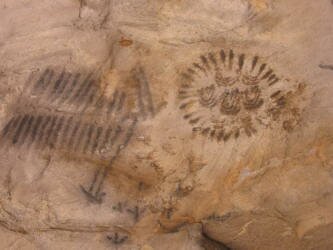
We enjoyed a lazy morning, relishing the coolness of the air after weeks of hot weather. Our camp is only about 1,800 feet high in elevation, but we have obviously come far enough south that we are now experiencing spring in South Australia. After we got ourselves moving, we traveled a short distance down the road to a set of caves filled with Aboriginal rock paintings. We climbed the trail up to the largest of the caves and saw a series of paintings that are understood to be descriptions of sacred ceremonies. |
We met up with the old Ghan Train line once again and joined it as it twisted its way through the winding and pretty Pichi Pichi Pass. As we came down the south side of the pass we passed into new territory, not desert but rather agricultural land filled with fields of wheat and barley. What a change. But we did pass by more historical stations that were nothing more than rock ruins, a few walls here and there. Despite the success of some farmers, others just couldn't make it though some of the droughts and hard times that hit this region. Despite glowing reports by the government back at the turn of 20th Century, the area was, and still is drought prone. Many prospective ranchers just couldn't make it here.
| Today also found us completing our north/south transverse across the center of Australia. We have successfully crossed from ocean to ocean, from the Top End - Darwin, across the center through Alice Springs and the Central Desert, to the south just outside Port Augusta. We're looking forward to relaxing along the coast, and the history of the copper producing area of the Yorke Peninsula. We made it as for south as Port Broughton, where we city camped near a long jetty built in the 1890's to load wheat onto ketches that would sail out to Clipper Ships waiting in the ocean and transfer their loads onto the ships bound for Europe. As the sun set, we realized that we had not only passed back into spring, but to early spring, because it was cold outside! We had to pull out our long pants and jackets for the first time since mid August. |
|
Oct 4
We had a surprising interruption of our day when we noticed that our rear bumper, the one that holds both of our spare tires, our bicycle rack and a couple of jerry cans of water, had developed a crack. We found a welder/repair center just in time as when we pulled into their driveway, the crack had weakened the bumper so much that it was actually flexing. Another few miles and we might just have lost our bumper! No worries though as we were able to repair and add more metal to make it stronger than it was originally.
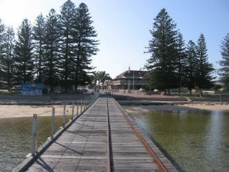
While the bumper was being repaired, we were able to spend time bike riding around Wallaroo, with its old stone buildings and its long jetty where wheat is loaded onto ships. We had a nice lunch at a restaurant at the jetty after riding out onto the jetty and talking with fishermen not having much luck trying to fill their baskets with crabs.
After our repair was finished, we made it a bit further south, to Port Hughes, where we found a great spot on the sand at the water's edge to set up camp. Just before sunset, we met several people who had come down to enjoy the beach and the sunset. We had a great time talking about the community, comparing it with our home town, and sharing past experiences that had similarities, and who shared with us, their favorite places along the Yorke Peninsula for us to visit.
Be sure to check out our Photo Index Page as we just added a new feature, "A Day in the Life" calendar with a representative photo from nearly everyday during the expedition.
|