|
Sept 17 - 23, 2007 Alice Springs area
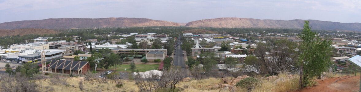
We arrived in Alice Springs (AS) and stopped at the local battery supplier to introduce ourselves, hoping that maybe our new batteries had arrived early. Since they hadn't, we made it an errand and chore day as we did laundry, grocery shopped and Don got a haircut.
AS is home to the School of the Air. School of the Air broadcasts lessons to children living in the Outback via satellite- linked webcams and HF radio. Lessons go out to an area comprising 1.3 million sq km. It is also home of the Royal Flying Doctors who have been been providing medical care for some 70 years to the people living on Aboriginal Communities and remote cattle stations. If you have a medical need, you can call in on your radio and explain the problem. You would get a consultation on the radio, and if necessary, a doctor would actually fly a plane out to assist you. These are two unique examples of how the Australians have learned to deal with the size and remoteness of their country.

Assuming that our batteries would arrive when they were originally expected, we headed out to the East MacDonnells Mountain Range for the next couple days.
|
|
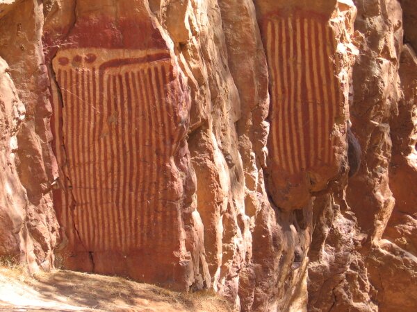
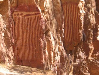
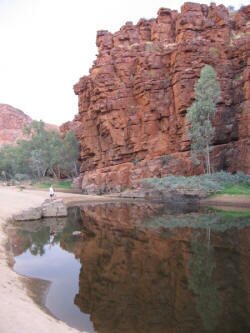
We explored two of the "gaps" in the range, slices in the mountains carved by millennia of water flows leaving behind gaps by which Aboriginals and explorers crossed the mountains. In Emily and Jessie Gaps we found ancient pictographs painted by the Eastern Arrernte Aboriginal people detailing one of the creation Dreamtime stories. This one is associated with the caterpillars that created many of the topographic features around Alice Springs and is one of the most sacred sites in the Alice Springs area. |
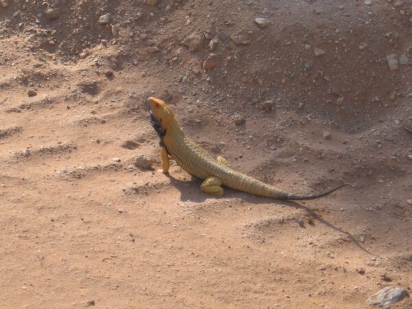
We then bush camped at Corroboree Rock, an interesting fan-shaped ridge of rock that in places had pieces missing so we could look through to the other side. This area is associated with the Perentie Dreaming Trail. The perentie are the large lizards that live in the area. It was here that we also saw our first Australian Ringneck parrots.
|
Sept 18 - 19
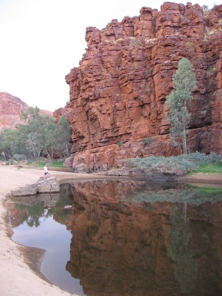
The next day we camped at Trephina Gorge Nature Park. In the morning we got up and moving early so that we could do a hike up along the rim of the gorge to view the red rock cliffs that line the gorge. We hiked back along the dry river bed and came across a deep pool where hundreds of small zebra finches were drinking - in between flying back to their roosts in the nearby trees. These finches are so small and fly so much that they need to drink from a water source one hundred times a day.
|
|
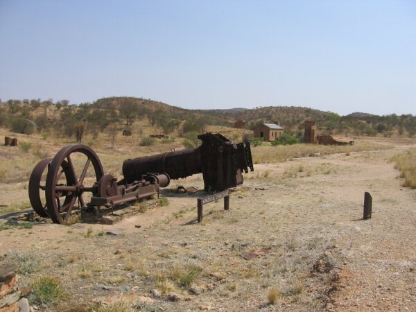
After a late breakfast we continued driving further into the East MacDonnells, following a four-wheel drive route to the ghost town/mining district of Arltunga. At the turn of the 19th Century, there was a gold rush here that brought desperate men to this area. We call these men desperate because they traveled by train to the end of the line some 600 km (372 miles) south of this place. From there, they walked, some pushing wheel barrels full of their possessions, following the recently completed telegraph line across the desert to Alice Springs, then across the mountains to this area. By today's standards, they mined gold worth about $6 million AU dollars. We're not sure that it was worth the effort as none of the miners ever became rich. On the road back to town we had to avoid the many dragons in the road. Dragons are the various lizards that live in this region, one of the more colorful ones is the bearded dragon.
Sept 20
First thing in the morning we drove back to Alice Springs to pick-up and install our brand new batteries for the living quarters of the expedition vehicle. Thank you East Penn Manufacturing for getting us batteries so far from home. Next on the agenda, we drove into the West MacDonnells Mountains NP.
Sept 21 - 23
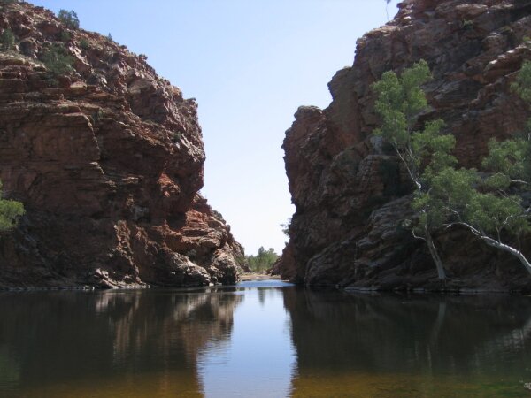
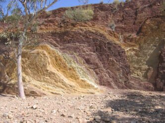
We explored several of the gorges on this side of the mountain range. Unlike the dry gaps of the east side, the gorges in the west had pools of water at their bases. Some of the pools were large enough to go swimming in, even though the water was very cold as it rarely receives any warmth from the sun. There was this gorge, that gorge, and Red something gorge. Actually they were the Ellery Creek Big Hole, Serpentine Gorge, Ormiston Gorge and Redbank Gorge. We also visited ochre pits where the Aboriginal people would collect the paints that they would use for decorating their bodies for ceremonies. The ochres come from weathered limestone and generally were yellows, whites, pinks and browns. These paints were also important trade items.
|

|
|
We made a surprising discovery along the way, unmentioned on any of our maps, that the West MacDonnells have several established bush camping sites. We took advantage of two of the sites, one of which was on a semi-permanent water hole. We watched for birds and animals at sunset. At one camp, we saw footprints of feral camels - but we didn't see any of the camels themselves.
Driving back into Alice Springs for the last time, we treated ourselves to lunch out at a restaurant, did some computer work at a local internet cafe, then headed south towards our next main point of interest, Uluru - what used to be called Ayers Rock back before the government returned the land to the local Aboriginal people. We camped overnight at a roadside stop.
Sept 24
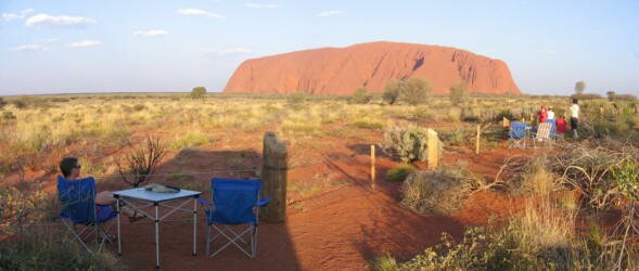
In the morning we continued toward the tourist town of Yulara. This is a town that was built to protect Uluru by keeping the human impact limited to one area Along the way we passed sand dunes of deep red sand which are the remnants of the mountain range that eroded into Uluru. Also along the way, we passed a huge mesa, Mt. Conner, reminiscent of the mesas in the American Southwest. Many tourists actually confuse it with Uluru - even though they look nothing alike.
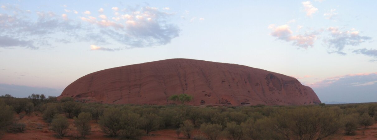
We finally got our first views of the famous rock just before we arrived at Yulara. It's a really big rock! We checked into the campground, then drove into the park and spent the next 5 hours visiting the cultural center and enjoying the different moods of the rock as we drove completely around it. As the temperature changes, and as the light changes, the sandstone reflects different aspects of the spectrum, making it appear that Uluru has moods. We stayed until after sunset, celebrating nightfall with loads of other people there doing nothing but enjoying the view.
Sept 25
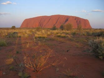
We set our alarm for an early morning wakeup so that we could be in place near the base of Uluru to view the colors as the sun rose. Although there were some clouds low on the horizon, we enjoyed watching the rock wake up.

After the sun rose, we made a hearty breakfast, then got our bicycles out to ride the 10 km/6.2 miles around the path at the base of the mountain. Walking/biking the trail is now the preferred way to experience Uluru as the traditional owners would prefer that people not climb the rock. People were allowed to climb before ownership was transferred back and the traditional owners agreed to leave it available, but it originally was only climbed as a sacred ceremony for men. We didn't see any other bicyclists and we appeared to be the envy of most of the walkers who commented on our bikes. We enjoyed the different close-up views and the Aboriginal sites and were glad we started early as the day got very hot when the temperature rose to 38°c/ 100°f.
| We made our way back to the campground where we hoped to relax until evening, but the wind picked up and blew fine red dust through the windows and onto everything. So after a couple of hours in camp, we headed back to the sunset viewing location and just relaxed there out of the blowing dust and sand. The weather was changing and the sky filled with clouds and it even sprinkled a very little amount of rain. But remarkably, the clouds parted as the sun reached the horizon and Uluru came alive. The colors were the fabulous reds that we had heard about. A perfect end to the day. |
|
Sept 26
Once again in the early morning we headed out, this time to Kata Tjuta, the other rock formation in the park. After watching these rocks change color during the sunrise, we got ready for our 7.4km/4.5mi hike through the rocks. This was a different experience, as we got to walk through (rather than just around) the rounded rock hills, some higher in elevation than Uluru and spread out along a larger area. Though not as famous as its neighbor Uluru, Kata Tjuta is also very impressive and beautiful.
After our hike, it was time to say our goodbyes to the rocks and head south. We made camp at a rest area on the border of the states of Northern Territory and South Australia on our drive south to the opal producing area of Coober Pedy.
|