|
Oct 13, 2007
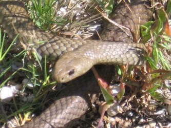
| After our restless night on the point, we took an opportunity between rain showers to take a hike around the area. After seeing a great opportunity for a photo, Don went back for the camera and on his return, almost stepped on a snake in the path. He then wisely found another way around. |
|
Leaving late in the morning, we drove slowly down the highway through the Coorong Natl. Park, stopping along the way to do some interpretive hikes. The first one involved hiking to a pelican breeding ground overlook. We could smell the pelicans (the guano) as soon as we got out of the car. The hike was nice, but the weather wasn't cooperative and we got caught in another rain shower.
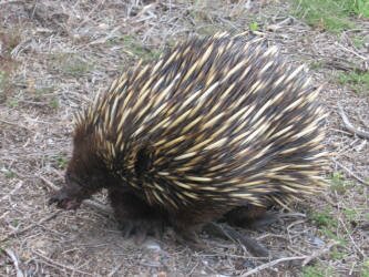
| Our second stop was a hike following the path of the Chinese miners that arrived on Australia's shore in the mid-1800's to mine gold. 10,000 people arrived in 1857 alone and Australians saw an opportunity to make money, guiding them to the goldfields hundreds of kilometers away. Some of the Chinese that arrived saw a different opportunity and built a well, a meal house and grew vegetables to feed the thousands who came after. Part of the trail included viewing the amazing craftsmanship of the well, and the quarry where the limestone blocks were cut to house it. Along the way we passed several echidnas. |
|
Oct 14
The next day saw us continuing our drive along the southern coast, visiting small villages and parks along the way. We spent some time in Cape Jaffa, Robe, the Little Dip Conservation Park and finally Beachport, camping on the shore of Lake George at the Beachport Conservation Park.
Oct 15
In the morning we drove to Millicent and ran some errands, finishing up after lunch. We then drove on to Mt. Gambier detouring down to the ocean to look at the small villages along the rough coastline.
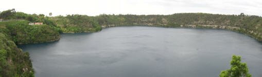
At Mt. Gambier we stopped to view the Blue Lake. The town is built on the slopes of an extinct volcano and the lake was formed when hot volcanic gases exploded and left behind a crater. The lake is at the water table level and that is what keeps it full. The remarkable thing about the lake, however, aside from the setting, is that it turns from grey to blue every November and in March it turns back to grey. We got lucky in that it started turning blue early this year and the color was incredible.
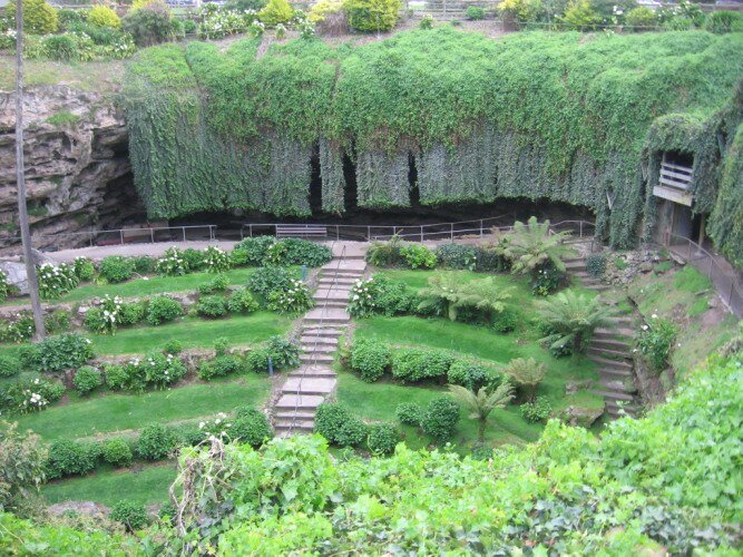
| Continuing into town, we stopped to view a couple of other lakes and then got out to visit a garden that was built in a huge sinkhole. The original owner of the property, entranced with the sinkhole, thought that it should be available for everyone to view and turned it into a garden and park. Uncared for after his death, the city purchased the property in the 1990's and set about cleaning it up and restoring it to its original state. Today it is a delightful park complete with picnic tables and BBQs called the Umpherston Sinkhole after the original owners. |

|
Oct 16
After a quiet night at a roadside stop at the border between the states of South Australia and Victoria, we drove north to visit The Grampians Nat'l. Park. The drive took us through different terrain as many of the fields have been turned into tree plantations, growing trees for wood and paper.
We stopped at a tourist information center in Hamilton and discovered that The Grampians park had had a huge fire in January, 2006 and was still recovering from it. Fearing the worst, we continued on our way and discovered that nature is amazing. While burned trees were still visible, much growth had returned and the overall look was green. We found a terrific bush camp site well off the main road.
Oct 17
We took an early morning walk along the road off of where we had camped, and found several different types of animal tracks in the soft sand. For sure one of the tracks was a kangaroo, but we couldn't ID the others.
Driving into the village of Halls Gap, we stopped at the Brambuk Cultural Center that also does double duty as the park visitor center. It was very professionally set up with an excellent display explaining the local Aboriginal groups and how they lived in the area. There were also displays where we could read about the places that we were hoping to hike within the Grampians. We also realized that we had forgotten to change our clocks forward half an hour after we crossed the border - oops.
|

|
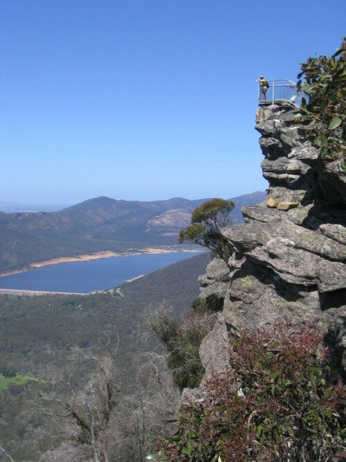
We took the Victoria Road that cuts across the park, in the process allowing us to drive across the mountain range. The route took us to a strenuous hike up the mountainside and through a deep gorge to a point called the Pinnacles Lookout, with a view point built on a rock ledge that stuck off the edge of the cliff about 1,000 feet above Halls Gap. What a climb, but what views! |
We continued up the mountains and stopped at two more magnificent view points, then did another hike to Broken Falls and Mackenzie Falls. Considering that the region has been in a severe drought, we were surprised to find the falls running quite full. After we got back to the Fuso, we noticed that it was nearly 5pm, so we quickly found a great bush camping spot nearby.
|