|
January 26-28, 2007
It was nice to finally finish up all of the duties that we had to take care of, now we could finally get down to the business of seeing the country. We were able to take care of some delayed maintenance on the Fuso and find a campground at the small village of Clark's Beach to spend our first night outside of Auckland. In the morning, we decided to stay off the main roads and stick to the small roads as that way we could visit the little towns along the way. We headed off down the west coast with the town of Raglan as our goal. Along the way we saw a lot of beautiful countryside and grazing sheep and cattle. Raglan is a cute little town that is famous for its surf. Surfers come here from all over the world to surf what is billed as the longest left hand break in the world. We drove out to the most famous beach to watch the surfers, but although there were a lot of people in the water waiting for the "perfect wave", not very many of them were catching it. The view from the cliffs above was quite spectacular though. We headed back into town to try to get a campsite at the holiday park on the shores of Raglan Harbour and the Opoturo River. This was a Friday night before a three day weekend (Auckland Anniversary Day on Monday) and the campground was sure to be busy. And busy it was. Fortunately we were able to get a site, but it sure gave us an idea of what commercial camping in New Zealand is all about. People in both tents and campervans crammed together in sites that had no barriers between them. Many of the sites had caravans (what the Kiwis call camping trailers) permanently parked with canvas rooms attached to the outside. The campground was so full that the only privacy provided was what people grant each other. Fortunately our spot, though only 4 spaces from the entrance of the park, was between two permanent trailers, only one of which was occupied. We faced our door toward the unoccupied trailer and placed our chairs toward the back of the site to give ourselves the most room possible. After getting settled in, we took a stroll along the beach and watched the birds on the shore. We also found a pillbox left over from World War II built on the shore of the harbour and the gravestone for a local Maori chief on the banks of the river.
A couple of hours later we stopped at a pullout overlooking Aotea Harbour for lunch. The view was interesting in that the tide was out and that had left the portion of the harbour we were visiting, high and dry. It would be a couple of hours before it was full of water again. After lunch we took advantage of the situation and hiked around looking at the oyster beds. We arrived at the town of Kawhia in mid-afternoon and proceeded to the sand dunes along the beach. The dunes were black sand and quite hot. When the tide is out it is possible to find hot springs coming up through the sand. Unfortunately for us, the tide was coming in. It was also quite windy and we debated about parking overnight in the car park at the beach or going back into the quaint little town and parking on the street. We chose the town. We spent the afternoon relaxing in the park bordering Kawhia Harbour and watching the tide come and go. The harbour is quite large but has a narrow entrance. Legend has it that the occupants of the Tainui canoe, the original Maori inhabitants, missed the entrance when they first arrived in the 14th century. The leaders of the canoe knew that the Tainui's home was destined to be on the west coast of the island, so they searched up and down the coast until they finally recognized their prophesied new home at Kawhia Harbour. The canoe is reputed to be buried on a hill overlooking the harbour and the location is considered sacred.
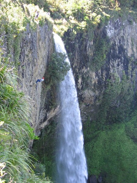
After a breakfast overlooking the harbour, we headed down the road toward the Waitomo Caves. Along the way we stopped at Marakopa Falls and the Mangapohue Natural Bridge Scenic Reserve. Both of these locations were only minutes walk off the road and were beautiful sites to visit. We eventually made our way to the Waitomo Caves area. The name Waitomo comes from the words wai (water) and tomo (hole or shaft). The name is appropriate as the area is littered with numerous shafts dropping abruptly into underground cave systems and streams. The area is also known for the glowworms that inhabit it. The main cave known as the Glowworm Cave had been known to the local Maoris for a long time, but the first European to explore it was shown the cave in 1887. Soon afterward, tourists started arriving and millions of people have visited since then. Wanting to experience both the underground systems and the glowworms, we chose a tour that would combine hiking and tubing down an underground stream. After meeting up with the rest of our group, we were driven to our starting point and outfitted with wetsuits, boots and helmets. Helmets? Uh oh, what have we gotten ourselves into? We then hiked a short way to the sinkhole that would allow us to access the underground stream. Climbing one at a time down a ladder, we squeezed ourselves into the subterranean passage. The next two hours were spent walking, crawling, squeezing, tubing and swimming underground, admiring stalactites, stalagmites, straw formations, curtain formations and flowstone, and oh, of course, gazing with wonder at the larvae of the fungus gnat, more poetically known as the glowworm. The larvae of the glowworms have luminescent organs which produce a soft greenish light. They hang suspended from an overhang weaving sticky threads for their prey (spiders, flies) to blunder into. They also provide entertainment for the many more tourists who choose to look for them. When we turned off our lights, the glow from the worms turned the roof of the cave into a miniature view of the Milky Way. Wanting to avoid another crowded campsite, we asked our caving guide for a freedom campsite recommendation. Taking his directions we ended up at the car park for the Ruakuri Cave. After dark, about 9pm, we put on our headlamps and headed down the trail to the cave. We had heard that we might be able to see more glowworms. After crossing a swaying suspension bridge and climbing up and down several staircases we were treated to some great displays of glowworm bioluminescence. As the light fades we could see more and more of their lights. We even got to see a small owl. |