|
February 26-March 2, 2007
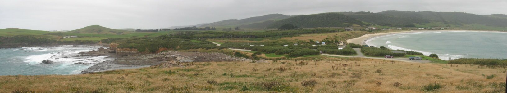
After a sleepless night in Bluff with the wind blasting and rocking and rolling us, we headed off along the very bottom of South Island traveling through farms and forests. There were so many ranches and fields of sheep that we lost count of their numbers. At one point, we crested a hill and found the road blocked by a long line of sheep being driven across the highway by the rancher to a shearing pen. The scenery, as promised by the Southern Scenic Route, was lovely. At lunchtime, we headed south to Curio Bay where there are actually twin bays separated by a peninsula. On the northeast side there is Porpoise Bay where Hector's Dolphins have been coming for hundreds of years to calve. The bay is still open to swimmers and kayakers but the interaction has in the past caused the dolphins to move elsewhere. Fortunately, when we were there, there were several dolphins visible, though none were playing in the surf (like in the pictures). But still it was cool to see this smallest and rarest of the dolphins (there are only 3,000 left in the world.)
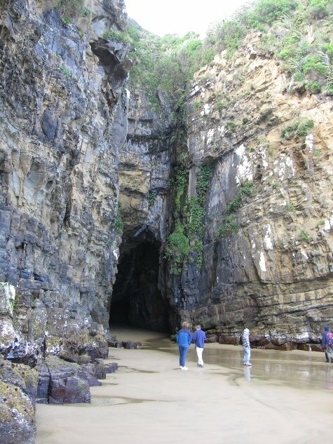
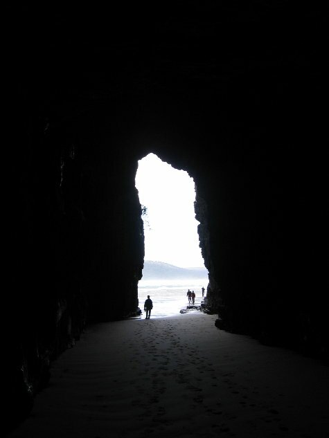
We continued on to Cathedral Caves which is located on private property. The Caves are only accessible at low tide, so the owners of the property restrict access until two hours before the lowest tide level. There is a gate just off the highway with a sign indicating when the gate will be opened. We had checked ahead for the time of the low tide and we arrived 15 minutes before the gate opened and parked out of the way. Waiting, we were able to watch other drivers attempt to deal with the fact that the gate was locked. One backed up and got in line in front of us, one spun their tires trying to get up the hill to get closer to the gate (they finally gave up), others parked willy-nilly and still others just gave up and left. It was a rather strange spectacle. Finally at 3:00, the owner arrived and unlocked the gate. There was a mad dash of cars trying to get in the gate (we can't mad dash to anywhere, so we just let them all pass us up) and a drive of 2km up the hill to the car park. After paying for our entrance, we hiked 15 minutes down a steep hill to the beach, and ten minutes along the beach to the caves. Because we were there when the gates opened, we were early in the outgoing tide. Also, because there was lots of wind, there was high surf, which affected how far the water went into the caves. We had been warned by the owner about the possibility of water coming in and to be on the lookout. We were able to get into the first cave by just waiting until the surf surge went out. The water was receding so it was no big deal. The first cave was quite narrow with a very high ceiling. It went back a long way and got very dark. Coming around a corner we were once again able to see light and were surprised to see that it hooked up with the second cave. We came out toward the front of the second cave and realized that the opening was still blocked by water. Several people were still trying to get around to the entrance of the first cave by waiting out the surge. However, a very large surge came and the people at the entrance had to scramble up the ledges to try to keep out of the water. We however, were forced to run back into the cave to outrun the water. We were successful, but the people on the ledges were not. They got wet up to their knees. We were all surprised at how far up the cave the water could still come, even though the tide was going out.
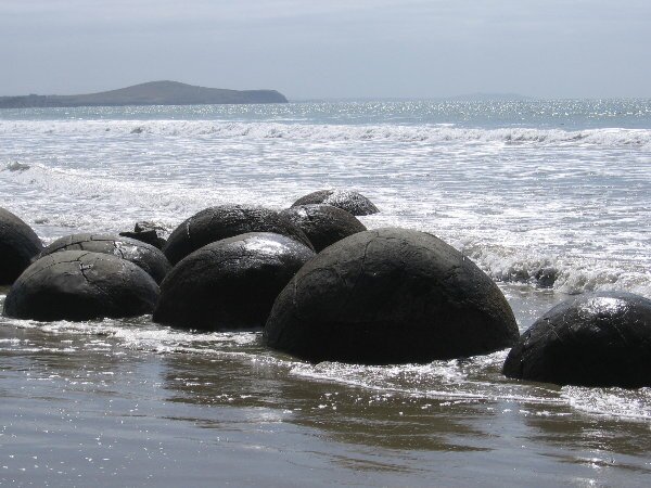
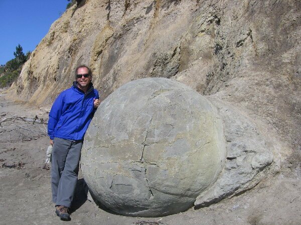
In the morning after taking our daily "coffee walk" one of the locals stopped by for a visit. As it turned out, her husband had waved to us as we drove by yesterday evening. Apparently Kiwis don't have any issue with people free camping, in fact it seems that they very much approve of it as they don't like to pay for camping any more than we do. She regaled us with stories about the beach that we were parked along, telling us about the fishing boats that used to moor here to unload their load of fish and oysters, and about some of the sordid stories in the more distant past. Leaving the Catlins behind us, we drove up along coast to the Otago Peninsula where we crossed it with a thrilling hair- raising drive over the hills on a narrow one lane road. We drove out to its furthest point to see some royal albatrosses flying over their nesting area, their only mainland nesting spot in the world. From the parking area we were able to spot a couple of the huge birds flying around the point, then we were able to get onto a rise behind the visitor's center and see the birds from much closer. Watching them soar was really beautiful. Being right at the end of the day, we looked for and found yet another great camping spot just a short distance away, right along the beach. Giving ourselves a treat in the morning, we decided to pack up early and go out for breakfast. It was nice to have a change as there are only so many different things to make for breakfast. Speaking of food, what do we eat while we're here in NZ? Pretty much the same thing as we do everywhere else. Just about all the fruits, vegetables and meats that we normally eat are available here too. The only difference is that the prices are a bit more than what we normally pay at home, and much higher than we had become accustomed to in South America. What is the saying - "Toto, I don't think we're in Kansas anymore." However, the meats are very good. We buy a lot of lamb or mutton, pork and even farm raised venison. The big treat is that live green mussels are farm raised in NZ and are available in nearly every bigger city at cheap prices. So we can treat ourselves every week to something that we'd only buy at home on special occasions. Driving northward, we passed through the cities of Dunedin and Oamaru. Not being fans of cities (we prefer to explore smaller towns where the local cultures are more evident) we enjoyed the historic buildings, did some more shopping and then moved along. A bit south of Oamaru, we stopped for lunch along the coast near some strange rocks that are found on the beach. What's strange about these rocks are that they spherical and that they were eroded out of the mudstone cliffs rather than being washed up onto the beach.
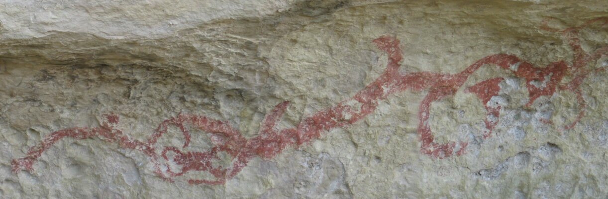
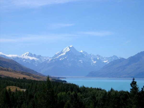
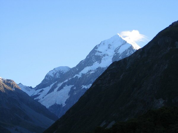
At this point, we decided to leave the east coast and cross back into the center of the South Island. We'll likely head up to the village of Mt. Cook to see the mountain from the eastern side and do some hikes up to its eastern glaciers. Just west of Oamaru, we found out about some great rock formations and the existence of a whale fossil. We managed to find the fossil, or rather the few bones that were left of it, but found the surrounding rocks more interesting. It turns out that the rocks were along an old coach line crossing the mountains and the travelers stopped here and carved their names in the soft sandstone and limestone rocks. What would now be called graffiti, these names are considered historical since they are about 100 years old. Just a couple of kilometers down the main highway, we stopped again at a rock overhang that contained Maori rock paintings. There used to be many more painting, but many were literally carved out of the rock and sold to museums around the world. We did manage to see the ones that were still there and were impressed by them.
After another fifteen minutes of driving we found a camp spot on an island in the middle of the Waitaki River. No we didn't have to drive across the river to get here, there are bridges on both side of the island to help the highway get across the river. We camped right next to the longest of the one lane bridges and set up camp near the jet boat ramp.
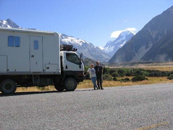
Today we were awakened before light by the raucous noise of the Kea parrots. Not only were they noisy, but they started landing on the Fuso's roof and picking at the silicone we use to waterproof the accessories on top. We hurriedly got dressed and went outside to shoo them away. What we found was about a dozen birds perched on the various campervans, chewing away. Shooed away, the started playing with various items around the campground, including the seat of a bicycle. These birds have huge beaks and can be very destructive. We had seen several signs around the country warning about their behavior and had never even seen any birds, but surprisingly, at the Mt. Cook campground there were no signs and lots of birds. There was also a researcher who was trying to net one of the birds, using various toys as bait, but these birds are very intelligent and refused to be caught.
|