|
February 14-19, 2007
After spending the night once again at the McKee Nature Reserve, we headed back to the town of Richmond where we had seen a Mitsubishi Fuso dealer. We had some questions regarding maintenance, so we stopped in. Our timing was just right as we were introduced to two representatives of Mitsubishi Fuso New Zealand. After chatting for a few minutes, we headed off to another repair place to have some work done. An hour later we were back on the road and looking for a spot to have lunch. After lunch we stopped at a winery for an afternoon tasting and continued on our way south and west toward the coast.
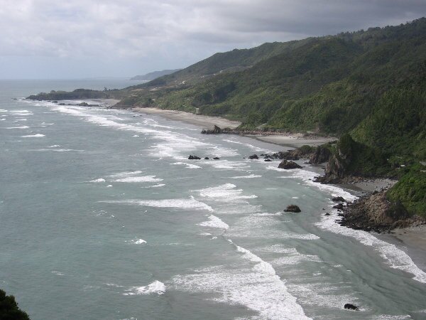
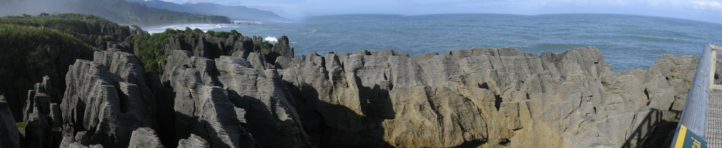
After battling the worst attack of sand flies so far (little black, flying, biting insects, New Zealand's dark secret that says "all is not perfect in paradise"), we got away from Lyell in the morning as quickly as we could and headed toward the coast. Along the way we drove through the very scenic Buller Gorge with its steep walls and fast moving river. We also passed under Hawks Crag, an overhang on the road that was hacked out of the rock. There was no sign indicating how high it was, but it looked OK. Lucky for us, the overhang still left us a couple of feet worth of space to fit under. It was just a little unnerving. We continued on to the town of Westport where we ran some errands and then hiked a trail along the coast to look at fur seals. While the seals were interesting, the scenery was beautiful. We continued our drive along the coast, ogling at more gorgeous scenery. A comparison in our guide book had been made to the California Big Sur coast and before we saw it, we scoffed, but it really was comparable with big trees, big rocks and crashing surf. We spent the night at a roadside rest stop in Punakaiki where the next day we could visit the "pancake rocks" and blowholes.
The next morning we were up bright and early so that we could take advantage of the high tide to get the best view of the blowholes that are famous on this stretch of coast. Well we don't know what happened, but the blowholes didn't do any performing so we occupied ourselves with enjoying the "pancake rocks" that are always performing. Scientists know that the layers of rock visible in this area are made of limestone and were formed underwater, they just don't know why or how. We came up with our own theories and then headed back on down the road.
Enjoying some more gorgeous coastline, we passed places with such unique names as Seventeen Mile Bluff, Fourteen Mile Bluff and Twelve Mile Bluff. We visited Greymouth (which really is a unique name), located at the mouth of the Grey River, and stopped for the night in Hokitika where we met some other travelers who were so interested in our travels that they bought us a beer and spent the afternoon asking questions and discussing traveling.
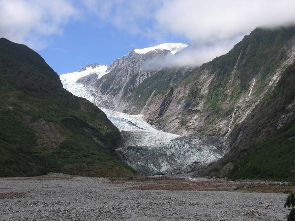
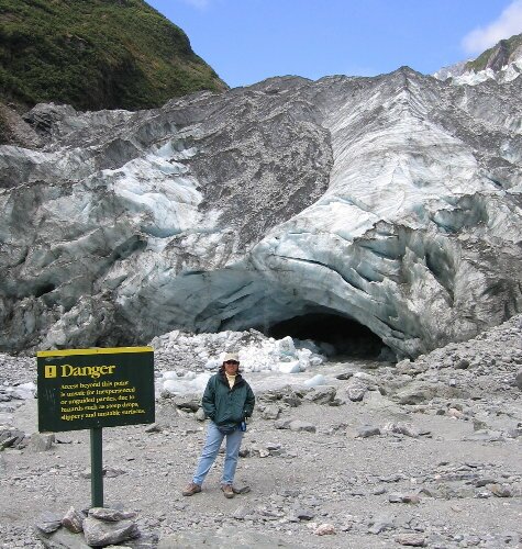
Continuing on our route southward, we arrived at the small beach village of Okarito. Beside claiming a Kiwi author as one of its 30 residents, the village is on the shoreline of the Okarito Lagoon. The lagoon is home to many species of birds, including a breeding colony of white herons, and is one of the few remaining places where kiwis' - NZ national bird - can still be found. We set up camp in the local campground and are looking forward to inflating our kayak for a spin around the lagoon tomorrow. Well, our clear skies abandoned us this morning and in its place we had a scattering of rain showers, not exactly enjoyable kayaking weather. After hanging out for a couple of hours, we threw in the towel, and drove down the road to the Franz Josef Glacier, our first NZ glacier. To our surprise, despite a sky full of clouds, the glacial valley was clear with sun shining down on the river of ice! We raced (ha!) down the road to the car park and headed down the trail to the foot of the glacier. The views along the road, and then the trail just kept getting better. At several places along the trail, which was in the rocky riverbed, we passed signs that warned of potential dangers and suggested that inexperienced hikers not proceed. In fact we had just a read a newspaper story about two hikers who went were they shouldn't have - into an ice cave - and were injured when the roof of the cave collapsed on them. Lucky for them experienced guides were nearby and rescued them. We knew better than to actually approach the glacier as its face was like a great, unstable cliff. We did walk along the river of icy water that poured forth out of a cave in the face of the glacier and posed for photos next to glacial ice that had run aground like miniature icebergs. We also watched as groups of people, lead by guides, climbed up steps that had been carved in the glacier's face hundreds of feet above the ground.
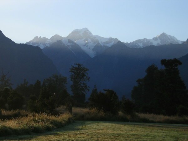
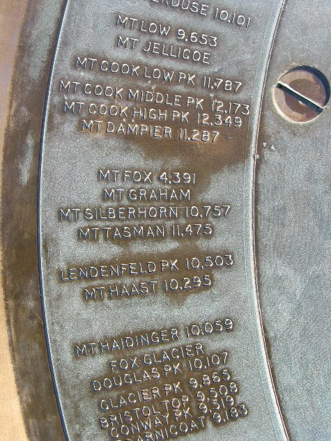
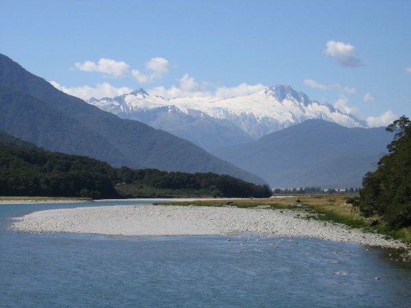
After getting back to town, we visited what must have been the world's smallest laundromat, 4 machines total and located in half of a small shipping container. Afterwards, we traveled another 25kms down the road to yet another glacier, the Fox Glacier. There are actually over 13 glaciers in the immediate area however only two are low enough in the mountains to be accessible to hikers. What we were hoping for, yes we were disappointed due to low clouds, was a view of Mt. Cook and Mt. Tasman - NZ's two tallest mountains. As it was late in the day, we satisfied ourselves with a hike around Lake Matheson, a lake formed in the last ice age, and made camp where, if lucky, we would see the mountains if tomorrow dawned clear. Surprise! The morning was crystal clear and as the sun rose there they were in all of their ice covered glory - Mt. Cook and Mt. Tasman. We set up our chairs to watch the day begin with this incredible view and had our morning cups of coffee. As the sun cleared the mountain tops, the sky became hazy and we bid our farewells to the mountains and moved on. However, we did drive down to the end of the road at the base of Fox Glacier and got an eye full of glacier. We could actually see just about the entire glacier, all the way up to the top of the mountain. Excellent.
The town of Haast is in the center of a major nature reserve that is included in the Southwest New Zealand (Te Wahipounamu) World Heritage Area. At the right time of year you can see fur seal and penguin colonies (not now) and there are lots of bird species to be viewed all year long. There is also the Haast Pass which follows the Haast River, a very scenic road along which there are several waterfalls and the glacial water in the river itself was an amazing aquamarine blue. Our drive during the day also afforded us views of numerous snow covered peaks and our campsite for the night was alongside the Makarora River surrounded by mountains.
|