October 3-8, 2006
Today was spent driving. There isn't anything in particular to see between Chachapoyas and the Peru/Ecuador border other than the beautiful scenery. So we drove slowly, trying to avoid the potholes and drop-offs while looking at the mountains and rivers and towns. Once back on the "paved" road, the pace picked up some but we still had to avoid potholes, drop-offs and washouts! The drop-offs are especially unnerving for whoever is currently sitting in the passenger seat as the views are straight down.
We made it as far as the outskirts of the town where the crossroads head north, before stopping at a police checkpoint for the night. There was a huge parking lot with no cars, but it took several minutes for the authorities to decide where it would be OK for us to park. After they decided, we parked and were level for the first time in a long time! It was hot outside, so we waited to have dinner until it cooled down and then we were able to sit outside under the lights (it was as bright as day out) and enjoy our dinner and the antics of the night hawks going after bugs brought out by the lights.
Another driving day today. The route we chose is the least used route of the three available to reach the border. It was only opened a few years ago after Peru and Ecuador made peace following their 1995 war over border issues. Originally there was only a ferry to take cars across the river, but recently a bridge was built. But the road from San Ignacio to the border is still dirt and we were concerned about the conditions.
We stopped at a police station at the crossroads and asked about the condition of the road ahead. Because we had friends that had difficulty driving in the rain on this road, we thought we would check first before committing to this route.
We were told by the police that the road was "pista" (paved) all the way to the next main town (San Ignacio). Sounds great. Except it wasn't quite true. The road might have been "pista" at one time, but after less than 50 miles the good pavement turned to bad and then non-existent. And then it started raining. Hmmm. Stopping the car and pow-wowing for a couple of minutes, we decided to continue on. Our options were to turn around and drive two days west on paved road or to take our chances. We decided to take our chances because we have four wheel drive in case we need it and we were already more than half way to the border. Besides the scenery was nice and the small towns interesting. The choice turned out to be the right one when the rain stopped and the road dried out.
In the middle of the afternoon we finally reached the border. After a couple of minutes of formalities on the Peru side (we had to get the immigration official out of his house), the gate was unlocked and lifted for us to cross the bridge. Just after the end of the bridge but before the gate on the Ecuador side, we snagged a low-hanging electrical wire on the roof of the truck. Fortunately we were able to grind to a halt before ripping it down and thus ending any chance of us getting into the country! Moving over to a higher spot, we passed safely under the wire and came to a stop at the Ecuador gate. After immigration formalities, we were greeted very warmly by the two customs officials and welcomed into the country after filling out one piece of paper and giving them copies of our passports, driving licenses and vehicle title. Let me repeat. Only one piece of paper required and copies of our documents. NO CARNET REQUIRED TO ENTER ECUADOR WITH A VEHICLE. This had been a worry even though we had found official documentation that said it hadn't been necessary for several years, but we hadn't met anyone who had crossed recently without one.
After being waved on our way with good wishes, we immediately found where our friends must have had their problems. The road rising up from the river was incredibly steep and narrow, and would have been extremely difficult to negotiate in wet weather. Fortunately for us, we were able to just drop the gears into low and slowly climb and climb and climb.
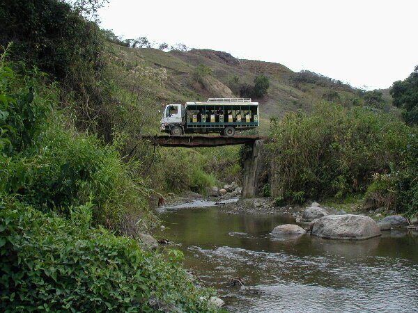
Along the way up we passed a really interesting vehicle, one that we would see throughout the rural areas of Ecuador, the Ranchero. The Rancheros are basically truck buses. On the back of small trucks similar to our Fuso, there are boxes with open sides and bench seats for passengers. In places where buses are less frequent these Rancheros are the main form of transport.
|
|
|
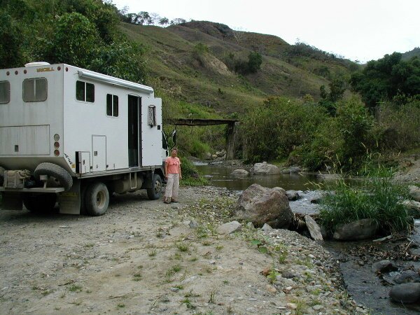
We finally leveled out and were able to enjoy the beautiful scenery. We passed through a couple of military checkpoints where we had to show our passports, but then we were quickly waved through. Just before sunset we found a fabulous spot to spend the night on the banks of a river (we actually forded the river) and were once again able to sit outside and enjoy the birds and the sound of rushing water.
In the morning we took our time getting started, just enjoyed sitting by the river drinking our coffee. A couple of local families came down to work the streambed, excavating sand and river rock by hand either for personal use or for sale. All the trucks and buses that drove by us honked their horns and the drivers waved to us in greeting. This was a nice welcome and bodes well that the Ecuadorians are very friendly.
About mid-morning it started to rain and the road started to get wet. It continued to rain and then the road got mucky. Plowing through, we had no problems, except for a really dirty underside. One of the interesting things about all of the towns that we went through, was that the main road was not a straight shot through town. In every town we had to make a number of turns in order to find our way through town. Sometimes we could find our own way by checking the heavy traffic marks and sometimes we had to ask directions. Signage in nearly all South American countries has been nearly non-existent so either we get lost trying to find our own way or we ask for directions - the quick and painless answer.
In the last town before Vilcabamba, we had to deviate around some piles of gravel in the road, but on the other side of the gravel there it was...Pavement!
Coming into Vilcabamba, which is known for its residents' longevity and beautiful location, we drove around town trying to find a good spot to park the Fuso. We finally found a new, yet-to-be opened restaurant with a large parking lot. The owner, Carlos, allowed us to park there for the two nights before the restaurant opened. It was a great spot, lots of room, quiet, water and a toilet dump.
The next day we visited the Rumi-Wilco Nature Reserve. We were able to walk from our parking spot and along the way we had to cross a bridge that had been washed out sometime in the past. The bridge was still usable as it still crossed the river, but it was at a really steep angle. Fortunately the handrails were still intact. Once we arrived at the reserve, we enjoyed the hike at the base of the mountains and along the river. We saw several new birds that we were unable to identify and several old standbys.
After a relaxing afternoon that included getting a one hour massage for $8.00US, we had dinner in town and a quiet night. The next morning we hit the road for Loja, our first big city in Ecuador. This is where we would pick up the Pan Americana again. Loja turned out to be quite a large city, but the road funneled us right into downtown, a 1/2 block from the bank where we were able to get some cash and right back out of town (with only one wrong turn). We stopped along the road for a typical Ecuadorian lunch (soup, chicken, rice, beans) which was very good and then continued on our way to the town of Saraguro.
Saraguro is an indigenous town, full of Saraguro indians. The men and women still wear traditional clothing which for the women consists of different styles of hats, black skirts, colorful blouses and black shawls held closed by antique silver pins. The men wear black hats, wear their hair in long ponytails down their backs, and wear white shirts with knee length black shorts. The preponderance of black in their wardrobe is said to represent their perpetual mourning for the assassination of their leader by the Inca 500 plus years ago.
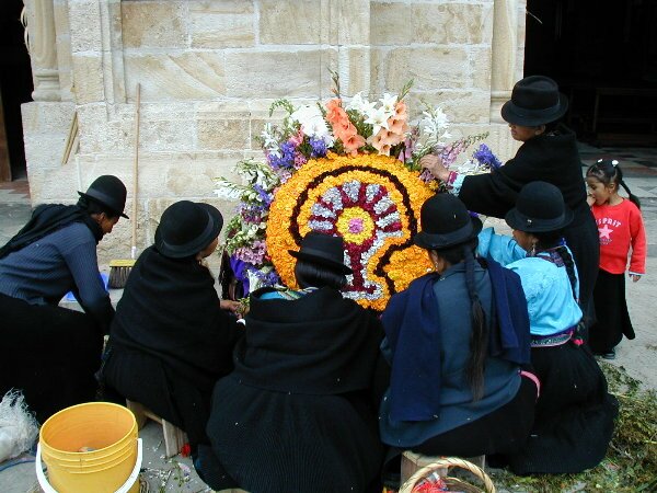
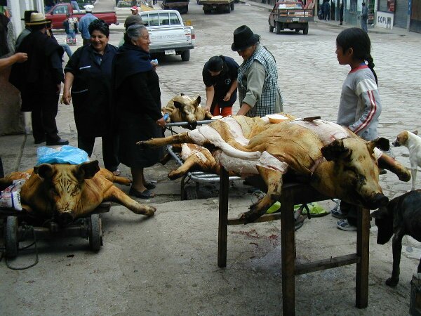
We enjoyed wandering around the town and visiting the market. We spent the night on a quiet street and in the morning we once again visited the market. The big draw in the morning were the smoked pig carcasses. People were lining up to purchase strips of smoked skin that they then sprinkled with salt before popping in their mouths. Everyone seemed to be enjoying it, but we couldn't bring ourselves to try it. Outside the main church, groups of Saraguro women were creating large (3ft across) flower arrangements that were later carried into the church by the men and positioned next to the altar as an offering.
|
|
|
We continued our drive to the major city of Cuenca passing over three mountain passes between 9,000 and 12,000 feet. After being forced to take a detour, we ended up in the town of Cuenca, which we had originally hoped to bypass in favor of the small town of Banos where there are thermal baths. We ended up having to negotiate our way around town (with only one wrong turn) before we found the Hosteleria Duran where we had our choice of thermal pools to soak in. We spent over an hour enjoying the heated waters before spending the night in the parking lot.