February 7
February 8
February 9
February 10
February 11
February 13
Bidding the whales farewell, today we are driving from the Pacific Coast to the Sea Of Cortez. The drive back down the whale road today seemed to be even worse than the drive out two days ago. Maybe the anticipation of seeing the whales made the drive go faster.
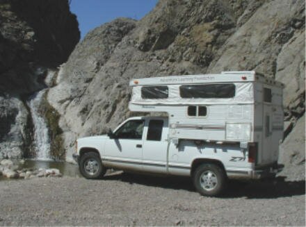
This morning we had a few questions about the satellite transmitter so I called the customer help department and got everything answered by Matt, a knowledgeable assistant. We then transmitted our updates and photos, packed up and hit the road.
This morning the lagoon was again foggy, but the fog burned off earlier than yesterday. We were treated to the sight of an Osprey (a fish eagle) carrying his catch. Seems that they always carry their fish head first. He even stopped nearby to eat it.
After bidding farewell to our new whale watching friends, Grant and Mary from Colorado, we were off. We stopped back on the highway at San Ignacio to refill our supplies, gas up the expedition vehicle and use our Performance Air compressor to fill our tires. We had "aired down" to make it easier on the tires when we took them over the rocky, washboard road. Then we headed south down the highway to the Sea of Cortez and our next stop at the old copper mining town of Santa Rosalia.
We passed by the "Volcano of the Three Virgins" as we drove through the Vizcaino Biosphere Reserve. We plan to explore the Reserve more thoroughly on our drive north in two weeks. The Reserve was set aside by the Mexican Government in 1988 and shortly thereafter it was recognized by the United Nations in the Man and Biosphere Program. This is the largest such reserve in Mexico and one of the largest in the world at over 2.5 million hectares of land. It was very green and even looked "lush", if you can call a desert that.
At about KM marker 17 we caught our first glimpse of the Sea of Cortez. The contrast of the blue of the water and the brown/green of the land was striking.
We pulled into the town of Santa Rosalia intent on finding a grocery and a laundromat. We were partially successful when we found a small mercado (market) and completely successful when we saw a sign for a RV park on the edge of town that had a washing machine! Small things like a washing machine can make us very happy.
More on Santa Rosalia tomorrow.
We started the day with a quick upload of our emails and journal updates. We then set off in search of a propane distributor to refill our cooking and heating bottle. The colder weather in Baja Norte nearly drained our propane supply. Fortunately we found a distributor just outside of town.
That gave us several hours to explore the unique town of Santa Rosaliá. For over 50 years at the turn of the 20th century, high-grade copper was mined here. A French company operated the mine and built the town. That is what gives the town its distinctive look.
Unlike the rest of Baja, the buildings here are constructed of wood with metal roofs. The result is the appearance of a French colonial plantation from the tropics.
Today the mining company is gone but the buildings remain. We explored the old smelter/foundry, visited the 120 year old Hotel Frances and walked around its wide verandah. There are even old mining train cars parked as monuments around town.
| The most unusual thing in Santa Rosaliá has to be the church. It is iron-walled with a metal roof and sides. It was designed by Alexandre Gustave Eiffel (as in the Eiffel Tower in Paris) in 1884. We have seen Eiffel's handiwork in buildings From Mexico to the Amazon and in Mozambique in Africa. | 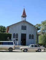 |
It was then time to continue south but first it was lunch time. We stopped in the small town of San Bruno to find a spot on the beach. We came upon some fishermen weighing up their catch and asked if we could purchase a fish. They agreed and we bought a huge halibut for about $1.60. Sure can't beat the price.
We then continued on to the town of Mulegé (mool-ay-hay), 65 km (40 miles) south and a world away. Mulegé is Baja's tropical village, a green oasis in the desert.
There are thousands of palm trees, colorful bougainvillea and even a river. Actually the Rio Mulegé is an estuary that extends about 3 miles inland from the Sea of Cortez.
Mulegé also has a great mission. We'll explore it tomorrow and try to get our inflatable kayak on the "river".
Now we have to find a quiet beach to set up camp and cook our fresh fish. Be sure to check out the new photos.
Today we visited the Misión Santa Rosalia de Mulegé. It was founded in 1766 by the Jesuits, destroyed by a chubasco in 1770 and rebuilt entirely of volcanic stone. It is a very impressive structure and it was in a really beautiful location. Walking around the back side, we found a path up to a view point. When we reached the top we gazed out over the Rio Mulegé and the thousands of date palms which surround the city.
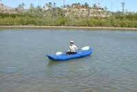 |
The Rio looked very inviting so we made our way to the other end of town following the river road. We passed many beautiful homes lining the river before we found a place to park the expedition vehicle. We then unpacked our Aire Inflatable kayak and got ready to put her in. |
As has happened several times on this expedition, a woman stopped to ask about ALF. We explained our purpose and goals, and she expressed interest in following along on-line. It is very rewarding to meet new people who are excited about ALF.
Anyway, we inflated the kayak and put into the river near the mouth of the estuary. We kayaked inland past sand bars lined by mangroves and occupied by many different species of birds. Mangroves are endangered as land becomes more scarce and developers fill them in to create more land to build on. We passed pelicans, little blue herons and snowy egrets. We saw kingfishers looking for lunch and ospreys hunting for the same. Unfortunately as the tide went out and the wind came up, the paddling became more difficult and we had to head back. On our return we passed a pelican trying to swallow a huge fish. As we passed he abandoned his attempt and let his catch go, to the delight of his competitors, the sea gulls.
After stowing the kayak and eating lunch we headed back to the highway. On the way we passed an airstrip and were treated to the sight of a small plane landing. Watching it bounce along the dirt runway at high speed was very exciting.
We then headed south toward Bahiá Concepción. Checking out each little bay along the way, we found beautiful, clean water set against beaches made of crushed shells. Deciding on Playa Escondida, we set up camp and spent the afternoon relaxing.
We also took advantage of the time to use our solar system and our Portawattz power inverter to charge the batteries for our computer and satellite systems.
The beach where we spent the night is at the north end of the very long Bahiá Concepción. The blue water in the Sea of Cortez becomes a milky blue due to the lime substances derived from the phenomenal number of shells that make up the "sand" on the beaches here. See the panorama photos!
The wind came up last night and was so strong that it shook the expedition vehicle all night long. This eliminated, for now, the possibility of kayaking in the bay. We didn't want to get blown out to sea! We'll stop again on our way north from Land's End.
As we headed down toward Loreto, we made an attempt to find the coyote pictograph that gives Bahiá Coyote its name. Despite having GPS coordinates and rough directions to the site, we found that our directions conflicted and would put us in two different locations. We chose the more likely spot to explore, but came up empty handed. Oh well.
Back on the road, about a 45 minute drive later, we got our first view of the rugged yet beautiful Sierra de la Giganta. Our destination for today lay deep within these mountains, the village of San Javier.
The hurricane that struck this area in October of 2001 caused major damage to the road, so four-wheel-drive was very helpful in places.
| After several miles of driving up and down steep grades and crossing the "Rio Loreto" (here it's just a stream) we reached an area where we found running water and palm trees. As we explored we even found rock art, pictographs made by the Cochimi people. The geometric patterns and designs are still little understood by anthropologists and archaeologists. | 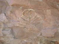 |
Deep on the valley floor, paralleling the road we were on, we could see the original "El Camino Real" built by the padres and the Indians nearly 300 years ago. This road eventually linked all the missions in Baja and Alta California.
After bumping along for 22 miles we arrived at the village of San Javier and the Jesuit mission, Misión San Francisco Javier Vigge Biaundó. The original mission was founded about 6 miles away in 1699, then moved to this location in 1720. The condition of the building and the magnificent canyon where it is located makes this one of the best missions in Baja.
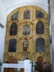 |
Unlike the majority of the Baja missions, San Javier was made from stone blocks. It took the Indian converts (conscripts?) 14 years to build the church. Inside are the original golden altar and paintings that were brought by burro and ship from Mexico City. The church even has its original bells, plus a third brought in 1803! |
We then turned our vehicle around and headed off in search of a camping spot.
This morning we awakened to only a slight breeze, perfect for taking a hike around the canyon we camped in. Last night we turned down a wash, actually the Rio Loreto, in search of a camping spot and took the first flat spot above the water that we found flowing.
| This morning as we were exploring the area, we discovered not 100 yards further down stream, there was a side canyon with a waterfall! We immediately decided to re-locate our camp to this spot and there were plenty of flat areas to park the vehicle. |
|
This was one of the places that having a Nature Pure undersink water purifier by General Ecology came in handy. We could refill our water supply and not have to worry about germs as the purifier removes everything that would make us ill. After taking care of some general housekeeping duties, we climbed up the side of the waterfall (more like a cascade, really) and went exploring.
The scenery up the canyon was absolutely beautiful. Very lush and green, with numerous species of cactus, some bushes with beautiful purple flowers and very interesting wild fig trees called Zaletas. After following the creek upstream for a while, we cut back over the top of the canyon to come back down to our campsite.
As we were nearing the area where we had initially camped, we became aware of the fact that we were walking on an old road. With its width and hand cleared margins it could only be part of the "El Camino Real", the Royal Road that connected the missions from Loreto north and south. Using Indian labor, the road was cleared of rocks and debris to a width of 8 - 10 feet. The debris was piled alongside the road creating a very distinctive road bed. This was obviously what we had stumbled upon. A very exciting discovery.
After our returning to our beautiful campsite and having lunch, it was time to move on.
We continued down the wash as it appeared that this was the unofficial road that the locals used. Within a few miles we were back at Hwy 1 and turned south to continue on our journey.
The highway turned inland about 36 KM (21.6 miles) south of Loreto. Crossing the peninsula through the Sierra de Giganta was absolutely gorgeous. The vistas of cactus and other vegetation were magnificent.
We continued on to Puerto Lopez Mateo where we hope to see some more gray whales and to kayak in the mangroves. More tomorrow!
Kayaking through the mangroves yesterday was fun and disappointing at the same time. Fun because the channels through the mangroves were narrow and wound around like a maze. In some places they were only as wide as the kayak. But it was disappointing because of the lack of birds! We had been hoping to see lots of migratory species spending the winter in the warmth of Baja but all we saw were two cormorants!
The night before we had viewed ospreys in their nests atop a line of telephone poles along the road. There were at least a half dozen nests and they were all occupied, but in the morning we didn't even see any ospreys flying overhead. Oh well. Maybe we'll have more luck back on the Sea of Cortez side.
As we were returning to our camp after kayaking, we could hear a boat engine somewhere in the maze. Thinking it was odd that a fisherman would come into the narrow channels, we just continued on our way with an ear tuned to the sound. As the engine sound got louder and louder however, we decided to get out of the center of the channel and get to the right side. Just before the boat came into view, we decided to grab onto the mangrove and pull ourselves over as far as possible. Just as we did, a Mexican Naval patrol boat came roaring around the bend. Their surprise/horror mirrored ours. They immediately powered down their engine and asked if we were OK. Nodding yes, we got our hearts started up again and we continued on our way.
Being aware of our surroundings and reacting to the situation certainly paid off in this situation. Doing nothing would certainly have gotten us run over. That would have been a drag!
After packing up the kayak and showering with our solar shower, we headed south to La Paz.