May 31
June 1
June 2
June 3
June 4
Today we drove the magnificent "Top of the World" highway to Dawson City, home of the largest gold rush in North American history.
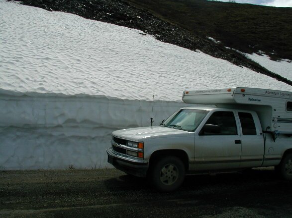
| The "Top of the World" highway gets its name from the fact that the road runs along the crest of 4,000 ft mountains nearly all the way from Dawson City to the USA/Canadian border. The views of the 100's of miles of surrounding mountains and valleys support its name. Along the road we passed snow drifts cut by snow plows just two weeks earlier that were as tall as the expedition vehicle. |
|
This area is also home to the caribou of the 40 Mile Herd. We were hoping to see some of the 25,000 caribou that make up the herd, but they must have been elsewhere in there migration. The history of the herd is stunning. As late as the 1920's the herd numbered more than 500,000 caribou. However, over hunting and other natural causes reduced the herd to as few as 6,000 animals by the 1990's! Conservation and hunting restrictions have helped the herd recover to where they are today. Yet in the late 1800's and early 1900's stories are told that the large herd would stop river traffic for days as the animals migrated across the rivers!
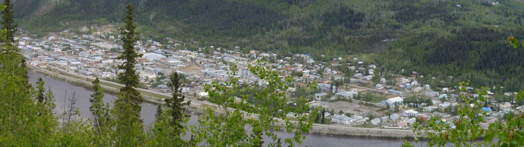
We arrived in Dawson City in the afternoon and stopped at the visitor's center. There we picked up a map of the town and proceeded on a self-guided walking tour to see the historic sites. Most of the buildings we visited were built between 1899 and 1902. We stopped by the old post office, staffed by a woman in period costume who hand-cancels the letters. We also walked by the Palace Grand Theatre which has been painstakingly restored, the Bank of British North America, the mortuary, the blacksmith shop and a number of buildings that had displays in the windows of the goods they had sold. We then got in the truck and drove by some old residences and the cemetery. Some of the original buildings are gone now, but the buildings that still exist have been lovingly restored and were very interesting to look at. The entire town is a Parks Canada site.
We stopped in one old store that had photos and comments from the time of the gold rush. The town was quite the rough and tumble place, with every available space taken by the tents of the stampeders. Many of the comments described the poor living conditions that the men lived in, the poor sanitation of the city and the high cost of living in Dawson City. We were constantly amazed at the magnitude and even the horror that these people went through in their efforts to strike it rich.
Our morning started with a walk along the shore of the mighty Yukon River. Looking out at the other shore nearly one-half mile away it was hard to imagine that this river was frozen so solidly less than a month earlier that vehicles could drive across the ice. We would be taking a ferry across it later.
|
This morning we were in search of a place called the "sternwheeler graveyard". What we found were five very old sternwheel paddleboats that had been dragged up on shore and abandoned some 50 years earlier. Although there wasn't much left to look at, we could make out some cabins, part of the wheelhouse and even one of the wheels that moved the boats. Their names, like Julia B and Seattlen conjured up visions of travel down the Yukon to Alaska or up to Whitehorse.
Read more about the sternwheeler that traveled the water highways of the far north. Follow this link. |

|
We continued our lessons about the crazy times that were the Klondike Gold Rush. We drove out to where it all started, Discovery Claim on Bonanza Creek. This is where on August 17, 1896 gold was discovered. Although the discovery started the gold rush among the seasoned prospectors already in the area that would become Dawson City, the true rush wouldn't begin until the next summer when steamships arrived in Seattle carrying "a ton of gold".
Today the original claim area is run by Parks Canada as a Klondike National Historic Site. Our drive up Bonanza Creek took us by the largest wooden bucket dredge in North America. More about that in a sec. The drive up the creek showed us the disturbing natural cost that resulted from the mining. The entire creek bed has been dredged and there are huge piles of tailings (the leftover mining debris) covering everything. The mining has also continued up the hillsides onto what are called "bench claims". These are claims that are above the creek level claims. The Klondike gold is unique in that it is found in a layer of white quartz gravel laid down millions of years ago during the time now called Beringia.
Of course gold is important to the economy of all countries that mine it and the natural cost has to be weighed against the economic benefit of the mining processes.
Back to the dredge I mentioned. The dredge is known as Dredge #4, the largest wooden bucket-line dredge in North America. The dredge operated from 1913 until 1959 - when it was sunk by a flood caused by the collapse of a dam upstream. #4 was built and delivered at the same time as its sister dredge #3 for a total of $800,000 US dollars. The dredge was actually manufactured in the United States, and shipped in pieces by boat and rail to Dawson City where it was constructed. So this $800,000 is in 1913 dollars. During the first year of operation of these two dredge, they returned not only enough money to pay for themselves, but enough to give their owner a profit of $800,000! This might give you an idea of why the Klondike gold rush gave people "gold fever". Be sure to read the Klondike Gold Rush page.
We learned that the dredges, like #4, could cover a total distance of one-half mile a year and at its best year, recover more than $3,000,000 a year. Now consider that one of the other gold bearing creeks, Hunker Creek, is 16 miles/26 km long and 13 miles/21 km have been dredged. The dredges were also incredibly loud and when they were digging into bedrock they created what felt like continuous earthquakes, and they ran 24 hours a day, 7 days a week, for a minimum of 200 days a year. What a neighbor they'd make! Read more about these fantastic machines. Follow this link.
After our dredge tour, we headed south on the Klondike Highway roughly following the trail of the stampeders (in reverse) to Whitehorse, then down to Skagway. From Skagway we'll board a ferry and continue the route back to the United States and the port of Bellingham just north of Seattle, Washington where it all began.
Today we took a boat out onto the Yukon River to get a feeling of what it was like to travel by boat to the gold fields at Dawson City. We chose a stretch of the Yukon from Minto to the abandoned town of Fort Selkirk. This stretch of river flows into the Yukon interior where there are no roads. From photos we have seen, the land looks the same as it did one hundred years ago.
Surprisingly, the Yukon is a very shallow river, this stretch averaged about 7 feet deep! Now we realize why only the shallow draft, steam powered sternwheeler boats could navigate this and other interior rivers.
Our destination, Fort Selkirk, started as a trading post set up at the site of a summer encampment of various First Nations People who came to fish and trade. A permanent settlement was established in 1892 and soon became the center of transportation and communications for the interior. Fort Selkirk was even considered as a possible location for the Yukon capital. This would all change as roads where cut into the interior and rivers lost their importance as transportation routes.
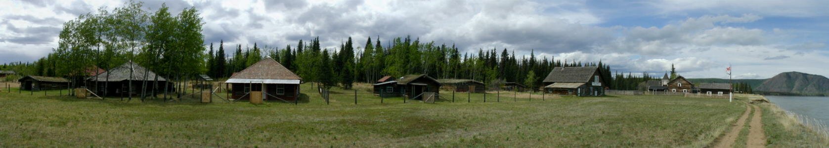
In 1950 the steamboats stopped running on the upper Yukon River and everybody in town simply picked up and moved to other towns. When they left, the people left their homes and many of their possessions in Fort Selkirk. Today the town is managed and preserved jointly by the Yukon government and the Selkirk First Nation. There are about 40 buildings still standing and open for exploring. The town is a time capsule into life at the turn of the 20th Century. On top of the history of the town there is the history of the Selkirk First Nation people that have been visiting this area for hundreds of years.
| We visited the First Nation people's cemetery and explored the unique traditions like the use of totems to indicate clan status and the use of symbolic painted designs on grave houses, also called spirit houses. Over time, the style of graves changed from the use of "spirit houses" to the use of elaborate grave fences with carved totems and later on, to store-bought wood and metal fences. Very interesting! |

|
Walking through the village and the buildings took us back in time. Some of the buildings still have furniture and a number of them had artifacts lying around. There were bottles that at one time contained medicines or food, chests for storage and buckets for carrying. One of the buildings toward the back of the complex still had old tin cans in a trash pile and their outhouse and doghouse were still intact. My favorite building belonged to the town handyman. In his workshop there were old tires from early cars, tools for working, an old engine and its parts and in the back, behind the shop, an old wood and metal pickup truck. It was falling apart, but it was still very interesting. Check out a Virtual Tour of Fort Selkirk.
We had an extremely enjoyable afternoon exploring this treasure trove.
We followed the Yukon River south for about 50 miles before it veered off into the interior. We'll meet the river again when we arrive in Whitehorse. Along the way though, we stopped where the river cuts through the Five Finger Rapids.
| The rapids where a navigational hazard for the early sternwheelers. The river cuts through a basalt formation weaving its way through four large outcroppings, only one of which is large enough for the boats to travel through - and only just barely. Some boats were known to have hit the rocks although none sank here. |

|
Later we stopped for a hike in an agate rockhounding area just to see what we could find. Well, we didn't find any cool agates due to the fact that there has recently been a flood in the canyon and everything was covered in a thick layer of dried mud. However we did find hundreds of foot prints of different animals that had wandered through while the mud was soft. The most interesting were the prints of a bear - the prints were as large as Don's hand. We figured that the bear would stand at least 6 feet tall!
We ended our day after stopping in Whitehorse to view one of the only two remaining sternwheelers in the Yukon, the SS Klondike. This ship was built in 1938 to replace the Klondike I that sank after running aground. The ship was wood burning and would burn 1 cord of wood every hour! A cord of wood would heat a typical Yukon home for 3 months in the dead of winter. The ship could steam to Dawson City in only a day and a half, although returning against the current would take 4 days.
Our destination today is the ghost town, or more accurately, the town site of Dyea. Dyea is about 9 miles from Skagway and during the Klondike Gold Rush it was the starting point for the stampeders due to its location at the start of the Chilkoot Trail.

|
On the way, we stopped at two interesting natural features. The first was Emerald Lake. Here the color of the lake takes on rainbow-like colors as a result of white sediment on the bottom. The sediment is derived from shells which reflect the blue-green light. |
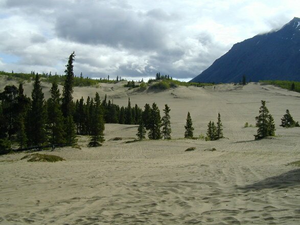
| The next stop was at the world's smallest desert, the Carcross Desert. How small? We drove through it in less than 2 miles. The sand comes from an old glacial lake bottom. |
|
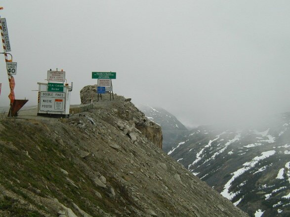
The remaining drive took us up and over the White Pass, one of two passes that the stampeders climbed to enter the Yukon.
| This pass was claimed to be easier than the Chilkoot because it is 500 feet shorter, however it was steeper and longer. One section was so bad that the pack horses the miners used died by the thousands, giving it the name Dead Horse Pass. Now the border between Canada and the USA is here. |
|
The poor weather gave us a feel for what the miners had to face as they climbed through here.
At the bottom of the pass we arrived at the outskirts of Skagway where we turned to explore the Dyea Townsite and hike a ways on the Chilkoot Trail. At the townsite we found only a few piles of decaying lumber and one storefront propped up with 2x4's. After the train was built out of Skagway the use of the Chilkoot dropped off and all 8,000 residents left Dyea, even taking their buildings with them!
We set up camp, then headed up to the trailhead so that we could spend several hours hiking the Chilkoot. Immediately we had to negotiate several long climbs over rocky terrain. The fact that the stampeders did this repeatedly, carrying their ton of provisions to the very top was mind boggling. It is really difficult to image anyone so desperate that they would endure such hardship. It would take the average stampeder a minimum of 30 days to carry their supplies 33 miles and 3,290ft/1,003m to the top of Chilkoot Pass.